Metal Print > Europe > United Kingdom > Scotland > Maps
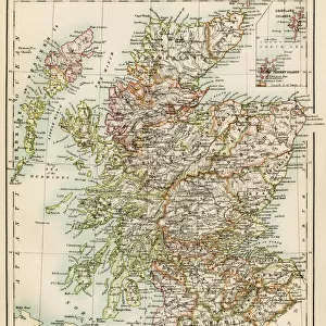
Metal Print : Old Map of Scotland 1852 by Henry George Collins

![]()
Metal Prints from MapSeeker
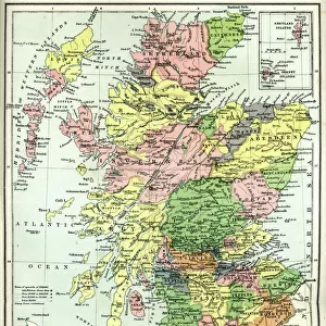
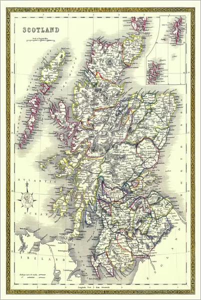
Old Map of Scotland 1852 by Henry George Collins
This is a finely detailed map of Scotland remastered from a rare Atlas of the World published in 1852 by Henry George Collins. Although these Henry Collins produced maps of the highest quality in his time unfortunately not the same could be said in terms of his business success. His maps were later obtained by the famous Stanford Map Company and used in their publications
Welcome to the Mapseeker Image library and enter an historic gateway to one of the largest on-line collections of Historic Maps, Nostalgic Views, Vista's and Panorama's from a World gone by.
Media ID 20347592
© Mapseeker Publishing Ltd
Collins Collins Atlas Collins Atlas Map Collins Map Old Map Of Scotland Old Scotland Map Old Scottish Map Scotland Scotland Map Scottish Map
16"x24" (61x41cm) Metal Print
Discover the rich history of Scotland with our stunning Media Storehouse Metal Print of the Old Map of Scotland 1852 by Henry George Collins. This intricately detailed map, remastered from the rare Atlas of the World published by Henry George Collins, showcases the beauty and complexity of Scotland during that era. Each metal print is meticulously crafted, bringing the historical map to life with vibrant colors and sharp details. The high-quality metal material adds a modern and sleek touch, making it a unique and captivating addition to any home or office decor. Transport yourself back in time and celebrate Scotland's rich heritage with this beautiful and collectible piece.
Made with durable metal and luxurious printing techniques, our metal photo prints go beyond traditional canvases, adding a cool, modern touch to your space. Wall mount on back. Eco-friendly 100% post-consumer recycled ChromaLuxe aluminum surface. The thickness of the print is 0.045". Featuring a Scratch-resistant surface and Rounded corners. Backing hangers are attached to the back of the print and float the print 1/2-inch off the wall when hung, the choice of hanger may vary depending on size and International orders will come with Float Mount hangers only. Finished with a brilliant white high gloss surface for unsurpassed detail and vibrance. Printed using Dye-Sublimation and for best care we recommend a non-ammonia glass cleaner, water, or isopropyl (rubbing) alcohol to prevent harming the print surface. We recommend using a clean, lint-free cloth to wipe off the print. The ultra-hard surface is scratch-resistant, waterproof and weatherproof. Avoid direct sunlight exposure.
Made with durable metal and luxurious printing techniques, metal prints bring images to life and add a modern touch to any space
Estimated Product Size is 41.2cm x 61.5cm (16.2" x 24.2")
These are individually made so all sizes are approximate
Artwork printed orientated as per the preview above, with portrait (vertical) orientation to match the source image.
FEATURES IN THESE COLLECTIONS
> MapSeeker
> Maps from the British Isles
> Scotland and Counties PORTFOLIO
> Arts
> Photorealistic artworks
> Detailed art pieces
> Masterful detailing in art
> Europe
> United Kingdom
> Scotland
> Maps
> Maps and Charts
> Popular Maps
> Maps and Charts
> Related Images
> Maps and Charts
> World
EDITORS COMMENTS
This beautifully preserved print showcases an exquisite "Old Map of Scotland 1852" by the talented cartographer, Henry George Collins. Remastered from a rare Atlas of the World published in 1852, this map is a testament to Collins' exceptional attention to detail and craftsmanship. Despite his undeniable talent, Collins faced unfortunate struggles in terms of business success during his time. However, fate had other plans for his remarkable maps as they were later acquired by the renowned Stanford Map Company. Recognizing their value and significance, these historic maps found new life within the pages of Stanford's prestigious publications. The "Old Map of Scotland 1852" transports us back in time to a period when cartography was both an art form and a scientific endeavor. Every contour line, river bend, and coastal feature has been meticulously rendered with precision and accuracy. This map offers not only geographical information but also glimpses into Scotland's rich history and cultural heritage. As we explore this vintage Scottish map, we are reminded that even though commercial success may have eluded Henry George Collins personally, his legacy lives on through these extraordinary works of art. The intricate details captured within this print allow us to appreciate both the beauty of Scotland's landscape and the skillful craftsmanship behind its creation.
MADE IN THE USA
Safe Shipping with 30 Day Money Back Guarantee
FREE PERSONALISATION*
We are proud to offer a range of customisation features including Personalised Captions, Color Filters and Picture Zoom Tools
SECURE PAYMENTS
We happily accept a wide range of payment options so you can pay for the things you need in the way that is most convenient for you
* Options may vary by product and licensing agreement. Zoomed Pictures can be adjusted in the Cart.