Metal Print > Arts > Artists > H > Jodocus Hondius
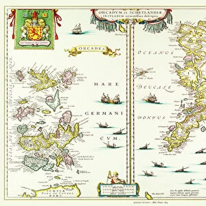
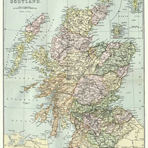
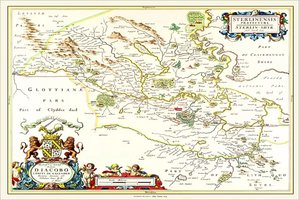
Metal Print : Old Map of Teviotdale Scotland 1654 from the Atlas Novus


![]()
Metal Prints from MapSeeker
Old Map of Teviotdale Scotland 1654 from the Atlas Novus
This detailed and most attractive reproduction map of Teviotdale, Scotland, has been carefully art worked from a scan of an antique original. The famous firm of Dutch cartographers and publishers was established in the late 16th century by Willem Janszoon Blaeu in Amsterdam. Blaeu was a maker of globes and scientific instruments and purchased some of his early map plates from Jodocus Hondius. From this small beginning was to emerge one of the largest and most prolific map publishing houses of the seventeenth century
Welcome to the Mapseeker Image library and enter an historic gateway to one of the largest on-line collections of Historic Maps, Nostalgic Views, Vista's and Panorama's from a World gone by.
Media ID 20348009
Blaeu Blaeu Family Blaue Map Historic Map Johan Blaeu Johan Blaeu Map Old Blaue Map Scottish Borders
16"x24" (61x41cm) Metal Print
Step back in time with our exquisite Metal Print of the Old Map of Teviotdale, Scotland from the Atlas Novus by MapSeeker. This intricately detailed reproduction captures the essence of history, meticulously crafted from a high-resolution scan of an original antique map. The Old Map of Teviotdale showcases the rich heritage of Scotland in 1654, with its intricate borders, topographical features, and historical landmarks. Our premium Metal Prints are not just a decorative addition to your space, they are a conversation starter and a journey through time. Experience the beauty and history with every glance, as the vibrant colors and textures come to life on the sleek, durable metal surface.
Made with durable metal and luxurious printing techniques, our metal photo prints go beyond traditional canvases, adding a cool, modern touch to your space. Wall mount on back. Eco-friendly 100% post-consumer recycled ChromaLuxe aluminum surface. The thickness of the print is 0.045". Featuring a Scratch-resistant surface and Rounded corners. Backing hangers are attached to the back of the print and float the print 1/2-inch off the wall when hung, the choice of hanger may vary depending on size and International orders will come with Float Mount hangers only. Finished with a brilliant white high gloss surface for unsurpassed detail and vibrance. Printed using Dye-Sublimation and for best care we recommend a non-ammonia glass cleaner, water, or isopropyl (rubbing) alcohol to prevent harming the print surface. We recommend using a clean, lint-free cloth to wipe off the print. The ultra-hard surface is scratch-resistant, waterproof and weatherproof. Avoid direct sunlight exposure.
Made with durable metal and luxurious printing techniques, metal prints bring images to life and add a modern touch to any space
Estimated Product Size is 61.5cm x 41.2cm (24.2" x 16.2")
These are individually made so all sizes are approximate
Artwork printed orientated as per the preview above, with landscape (horizontal) orientation to match the source image.
FEATURES IN THESE COLLECTIONS
> MapSeeker
> Maps from the British Isles
> Scotland and Counties PORTFOLIO
> Arts
> Artists
> B
> Willem Blaeu
> Arts
> Artists
> H
> Jodocus Hondius
> Arts
> Photorealistic artworks
> Detailed art pieces
> Masterful detailing in art
> Europe
> United Kingdom
> Scotland
> Maps
> Europe
> United Kingdom
> Scotland
> Scottish Borders
> Related Images
> Maps and Charts
> Early Maps
> Maps and Charts
> Related Images
> Maps and Charts
> Willem Janszoon Blaeu
EDITORS COMMENTS
This beautifully crafted print showcases an exquisite reproduction of the "Old Map of Teviotdale Scotland 1654" from the renowned Atlas Novus. Meticulously art worked from a scan of an antique original, this map offers a fascinating glimpse into the historical geography of Teviotdale, Scotland. The origins of this remarkable piece can be traced back to Willem Janszoon Blaeu, a skilled Dutch cartographer and publisher who established his firm in Amsterdam during the late 16th century. Initially known for crafting globes and scientific instruments, Blaeu's passion for maps led him to acquire some early map plates from Jodocus Hondius. Little did he know that this humble beginning would pave the way for one of the largest and most prolific map publishing houses of the seventeenth century. With its intricate details and captivating aesthetics, this historic map transports us back in time to explore Teviotdale's past. It serves as a testament to Johan Blaeu's legacy within the Blaeu family and their significant contributions to cartography. Whether you're an avid history enthusiast or simply appreciate fine craftsmanship, this old map is sure to captivate your imagination. Discover Teviotdale like never before with this extraordinary piece that celebrates both its rich heritage and artistic excellence.
MADE IN THE USA
Safe Shipping with 30 Day Money Back Guarantee
FREE PERSONALISATION*
We are proud to offer a range of customisation features including Personalised Captions, Color Filters and Picture Zoom Tools
SECURE PAYMENTS
We happily accept a wide range of payment options so you can pay for the things you need in the way that is most convenient for you
* Options may vary by product and licensing agreement. Zoomed Pictures can be adjusted in the Cart.