Metal Print > Europe > United Kingdom > Wales > Maps
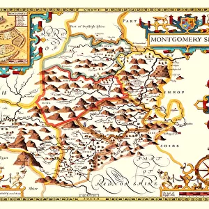
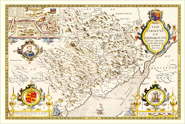
Metal Print : Old County Map of Monmouthshire 1611 by John Speed


Metal Prints from MapSeeker
Old County Map of Monmouthshire 1611 by John Speed
A facimile of John Speeds historical map of Monmouthshire originally published for the " Theatre of the Empire of Great Britain", an atlas to accompany " a history of Great Britain"
Welcome to the Mapseeker Image library and enter an historic gateway to one of the largest on-line collections of Historic Maps, Nostalgic Views, Vista's and Panorama's from a World gone by.
Media ID 20347765
© Mapseeker Publishing Ltd
County Map County Map Of Wales Historic Map John Speed Map Old County Map Old Welsh County Map Speed Map Speede Map Welsh County Map Monmouthshire
16"x24" (61x41cm) Metal Print
Step back in time with our exquisite Metal Print of the Old County Map of Monmouthshire, originally published by renowned cartographer John Speed in 1611. This stunning reproduction, sourced from MapSeeker, showcases intricate details of Monmouthshire's historical landscape. The metallic finish adds a modern, contemporary twist to this antique map, making it a unique and captivating addition to any room. Bring history to life with this beautiful piece of wall art.
Made with durable metal and luxurious printing techniques, our metal photo prints go beyond traditional canvases, adding a cool, modern touch to your space. Wall mount on back. Eco-friendly 100% post-consumer recycled ChromaLuxe aluminum surface. The thickness of the print is 0.045". Featuring a Scratch-resistant surface and Rounded corners. Backing hangers are attached to the back of the print and float the print 1/2-inch off the wall when hung, the choice of hanger may vary depending on size and International orders will come with Float Mount hangers only. Finished with a brilliant white high gloss surface for unsurpassed detail and vibrance. Printed using Dye-Sublimation and for best care we recommend a non-ammonia glass cleaner, water, or isopropyl (rubbing) alcohol to prevent harming the print surface. We recommend using a clean, lint-free cloth to wipe off the print. The ultra-hard surface is scratch-resistant, waterproof and weatherproof. Avoid direct sunlight exposure.
Made with durable metal and luxurious printing techniques, metal prints bring images to life and add a modern touch to any space
Estimated Product Size is 61.5cm x 41.2cm (24.2" x 16.2")
These are individually made so all sizes are approximate
Artwork printed orientated as per the preview above, with landscape (horizontal) orientation to match the source image.
FEATURES IN THESE COLLECTIONS
> MapSeeker
> Maps from the British Isles
> Wales and Counties PORTFOLIO
> Arts
> Artists
> S
> John Speed
> Europe
> United Kingdom
> Wales
> Maps
> Europe
> United Kingdom
> Wales
> Monmouthshire
> Related Images
> Europe
> United Kingdom
> Wales
> Posters
> Europe
> United Kingdom
> Wales
> Related Images
> Maps and Charts
> British Empire Maps
> Maps and Charts
> Early Maps
> Maps and Charts
> Related Images
> Maps and Charts
> Wales
EDITORS COMMENTS
This stunning print showcases the intricate details of the "Old County Map of Monmouthshire 1611" by John Speed. As a faithful reproduction of Speed's historical map, originally published for the renowned "Theatre of the Empire of Great Britain" this facsimile offers a captivating glimpse into the past. With its rich history and cultural significance, Monmouthshire comes to life in this old Welsh county map. Every line and contour tells a story, revealing the evolution and development of this remarkable region. From quaint villages to majestic castles, each landmark is meticulously depicted, providing an immersive experience for any history enthusiast or admirer of cartography. John Speed's expertise as both a historian and cartographer shines through in every stroke on this speede map. It serves as an invaluable resource for those seeking to explore the roots and heritage of Monmouthshire or delve deeper into British history as a whole. Whether displayed in your home or office, this historic map adds character and intrigue to any space. Its timeless charm invites you to embark on a visual journey through time while appreciating the artistry behind it. Step back in time with this extraordinary piece that captures not only Monmouthshire's essence but also celebrates John Speed's contribution to mapping our world. Discover why maps are more than just geographical representations; they are gateways into our collective pasts.
MADE IN THE USA
Safe Shipping with 30 Day Money Back Guarantee
FREE PERSONALISATION*
We are proud to offer a range of customisation features including Personalised Captions, Color Filters and Picture Zoom Tools
SECURE PAYMENTS
We happily accept a wide range of payment options so you can pay for the things you need in the way that is most convenient for you
* Options may vary by product and licensing agreement. Zoomed Pictures can be adjusted in the Cart.