Metal Print > Arts > Photorealistic artworks > Detailed art pieces > Masterful detailing in art
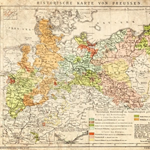
Metal Print : Old Map of Prussia 1852 by Henry George Collins


![]()
Metal Prints from MapSeeker
Old Map of Prussia 1852 by Henry George Collins
This is a finely detailed map of Prussia remastered from a rare Atlas of the World published in 1852 by Henry George Collins. Although these Henry Collins produced maps of the highest quality in his time unfortunately not the same could be said in terms of his business success. His maps were later obtained by the famous Stanford Map Company and used in their publications
Welcome to the Mapseeker Image library and enter an historic gateway to one of the largest on-line collections of Historic Maps, Nostalgic Views, Vista's and Panorama's from a World gone by.
Media ID 20347430
© Mapseeker Publishing Ltd
Collins Collins Atlas Collins Atlas Map Collins Map Prussia
16"x24" (61x41cm) Metal Print
Step back in time with our exquisite Metal Print of the Old Map of Prussia 1852 by Henry George Collins from MapSeeker. This finely detailed map, remastered from a rare Atlas of the World published in 1852, showcases the historical geography of Prussia with intricate lines and vibrant colors. The high-quality metal print gives a contemporary twist to this antique map, making it a stunning addition to any home or office decor. Relive history with this unique and captivating piece.
Made with durable metal and luxurious printing techniques, our metal photo prints go beyond traditional canvases, adding a cool, modern touch to your space. Wall mount on back. Eco-friendly 100% post-consumer recycled ChromaLuxe aluminum surface. The thickness of the print is 0.045". Featuring a Scratch-resistant surface and Rounded corners. Backing hangers are attached to the back of the print and float the print 1/2-inch off the wall when hung, the choice of hanger may vary depending on size and International orders will come with Float Mount hangers only. Finished with a brilliant white high gloss surface for unsurpassed detail and vibrance. Printed using Dye-Sublimation and for best care we recommend a non-ammonia glass cleaner, water, or isopropyl (rubbing) alcohol to prevent harming the print surface. We recommend using a clean, lint-free cloth to wipe off the print. The ultra-hard surface is scratch-resistant, waterproof and weatherproof. Avoid direct sunlight exposure.
Made with durable metal and luxurious printing techniques, metal prints bring images to life and add a modern touch to any space
Estimated Product Size is 61.5cm x 41.2cm (24.2" x 16.2")
These are individually made so all sizes are approximate
Artwork printed orientated as per the preview above, with landscape (horizontal) orientation to match the source image.
FEATURES IN THESE COLLECTIONS
> Arts
> Photorealistic artworks
> Detailed art pieces
> Masterful detailing in art
> Maps and Charts
> World
EDITORS COMMENTS
This beautifully preserved print showcases an exquisite "Old Map of Prussia 1852" by the talented cartographer Henry George Collins. Remastered from a rare Atlas of the World published in 1852, this map offers a glimpse into the rich history and intricate details of Prussia during that time. Henry Collins was renowned for his exceptional craftsmanship, producing maps of unparalleled quality. However, despite his remarkable talent, he faced challenges in terms of business success. Fortunately, his invaluable maps found their way into the hands of the prestigious Stanford Map Company, who recognized their significance and incorporated them into their own publications. The map itself is a testament to Collins' meticulous attention to detail. Every contour line and geographic feature has been expertly rendered, providing an accurate representation of Prussia's landscape in 1852. From its major cities to its rivers and borders, this old map serves as both a historical artifact and a work of art. As we explore this piece, we are transported back in time to witness Prussia's grandeur before it became part of modern-day Germany. It allows us to trace the footsteps taken by generations past across its vast territories. With each glance at this extraordinary print, we gain insight into not only Prussian history but also appreciate Henry George Collins' enduring legacy as one of the finest cartographers ever known.
MADE IN THE USA
Safe Shipping with 30 Day Money Back Guarantee
FREE PERSONALISATION*
We are proud to offer a range of customisation features including Personalised Captions, Color Filters and Picture Zoom Tools
SECURE PAYMENTS
We happily accept a wide range of payment options so you can pay for the things you need in the way that is most convenient for you
* Options may vary by product and licensing agreement. Zoomed Pictures can be adjusted in the Cart.