Metal Print > Maps and Charts > Related Images
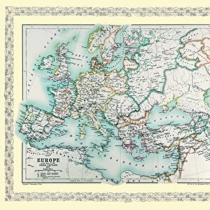
Metal Print : Map of Europe showing how it appeared in the year AD 1740


![]()
Metal Prints from MapSeeker
Map of Europe showing how it appeared in the year AD 1740
EHIST010
Welcome to the Mapseeker Image library and enter an historic gateway to one of the largest on-line collections of Historic Maps, Nostalgic Views, Vista's and Panorama's from a World gone by.
Media ID 20348272
Europe Europe Map Map Of Europe
16"x20" (51x41cm) Metal Print
Step back in time with our exquisite Media Storehouse Metal Print of the MapSeeker Map of Europe from AD 1740 (EHIST010). This beautifully detailed metal print showcases the European continent as it looked over 300 years ago. The vintage map design is meticulously transferred onto a durable metal sheet, giving it a unique and timeless appeal. Hang it up in your home or office to add a touch of historical charm and intrigue to any space. With its high-quality finish and protective coating, this metal print is not only a stunning decor piece but also a long-lasting investment. Travel back in time and explore the historical geography of Europe with this captivating and authentic reproduction.
Made with durable metal and luxurious printing techniques, our metal photo prints go beyond traditional canvases, adding a cool, modern touch to your space. Wall mount on back. Eco-friendly 100% post-consumer recycled ChromaLuxe aluminum surface. The thickness of the print is 0.045". Featuring a Scratch-resistant surface and Rounded corners. Backing hangers are attached to the back of the print and float the print 1/2-inch off the wall when hung, the choice of hanger may vary depending on size and International orders will come with Float Mount hangers only. Finished with a brilliant white high gloss surface for unsurpassed detail and vibrance. Printed using Dye-Sublimation and for best care we recommend a non-ammonia glass cleaner, water, or isopropyl (rubbing) alcohol to prevent harming the print surface. We recommend using a clean, lint-free cloth to wipe off the print. The ultra-hard surface is scratch-resistant, waterproof and weatherproof. Avoid direct sunlight exposure.
Made with durable metal and luxurious printing techniques, metal prints bring images to life and add a modern touch to any space
Estimated Image Size (if not cropped) is 50.8cm x 40.6cm (20" x 16")
Estimated Product Size is 51.4cm x 41.2cm (20.2" x 16.2")
These are individually made so all sizes are approximate
Artwork printed orientated as per the preview above, with landscape (horizontal) orientation to match the source image.
FEATURES IN THESE COLLECTIONS
> MapSeeker
> Maps of Europe
> Old Maps of Europe and Small Islands of
> Maps and Charts
> Related Images
EDITORS COMMENTS
This print showcases a historically significant artifact, the "Map of Europe showing how it appeared in the year AD 1740". A visual time capsule, this map offers a glimpse into the intricate political landscape and territorial boundaries that defined Europe during that era. With meticulous detail and expert cartography, this map presents an accurate representation of European countries as they stood more than two centuries ago. It allows us to trace the contours of nations long gone or transformed over time, providing valuable insights into geopolitical shifts and historical events. The vibrant colors used in this print bring life to each country's borders, highlighting their unique identities within a complex tapestry. From mighty empires like Prussia and Austria to smaller kingdoms such as Portugal and Sweden, every nation is meticulously labeled with its respective name. Beyond its aesthetic appeal, this map serves as a powerful educational tool for history enthusiasts and scholars alike. It invites exploration of past alliances forged through treaties or shattered by conflict. By examining Europe's political divisions in 1740, we gain deeper understanding of subsequent developments leading up to modern-day borders. Whether displayed in classrooms or personal collections dedicated to historical artifacts, this print from MapSeeker preserves an invaluable piece of European history. Its presence sparks curiosity about our shared past while reminding us how geography has shaped our present reality.
MADE IN THE USA
Safe Shipping with 30 Day Money Back Guarantee
FREE PERSONALISATION*
We are proud to offer a range of customisation features including Personalised Captions, Color Filters and Picture Zoom Tools
SECURE PAYMENTS
We happily accept a wide range of payment options so you can pay for the things you need in the way that is most convenient for you
* Options may vary by product and licensing agreement. Zoomed Pictures can be adjusted in the Cart.