Metal Print > Arts > Artists > L > Antonio Lafreri
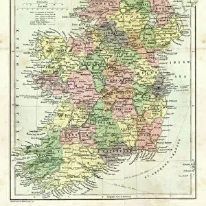
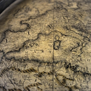
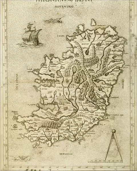
Metal Print : Hybernia Nunc Irlant. Ireland. Map


![]()
Metal Prints from Mary Evans Picture Library
Hybernia Nunc Irlant. Ireland. Map
Hybernia Nunc Irlant. Ireland. Map was clearly made by a member of the Lafreri School of cartographers, Antonio Lafreri (1512-77). Rome, 1570. Renaissance. Engraving by Paolo Forlani, 16th C
Mary Evans Picture Library makes available wonderful images created for people to enjoy over the centuries
Media ID 14337075
© Thaliastock / Mary Evans
Antoni Antonio Cartography Forests Hibernia Mapping Renaissance Rivers Lafreri
16"x20" (51x41cm) Metal Print
Discover the rich history and culture of Ireland with our stunning Metal Prints featuring the iconic Hybernia Nunc Irlant map. This exquisite piece, sourced from the renowned Mary Evans Prints Online, is a captivating representation of Ireland during the Renaissance era. Produced by the esteemed Lafreri School of cartographers, led by Antonio Lafreri, and expertly engraved by Paolo Forlani, this 16th-century masterpiece is now available in a modern, vibrant metal print format. Bring the intriguing stories of Ireland's past into your home or office, and elevate your space with this beautiful and unique work of art.
Made with durable metal and luxurious printing techniques, our metal photo prints go beyond traditional canvases, adding a cool, modern touch to your space. Wall mount on back. Eco-friendly 100% post-consumer recycled ChromaLuxe aluminum surface. The thickness of the print is 0.045". Featuring a Scratch-resistant surface and Rounded corners. Backing hangers are attached to the back of the print and float the print 1/2-inch off the wall when hung, the choice of hanger may vary depending on size and International orders will come with Float Mount hangers only. Finished with a brilliant white high gloss surface for unsurpassed detail and vibrance. Printed using Dye-Sublimation and for best care we recommend a non-ammonia glass cleaner, water, or isopropyl (rubbing) alcohol to prevent harming the print surface. We recommend using a clean, lint-free cloth to wipe off the print. The ultra-hard surface is scratch-resistant, waterproof and weatherproof. Avoid direct sunlight exposure.
Made with durable metal and luxurious printing techniques, metal prints bring images to life and add a modern touch to any space
Estimated Image Size (if not cropped) is 40.6cm x 50.8cm (16" x 20")
Estimated Product Size is 41.2cm x 51.4cm (16.2" x 20.2")
These are individually made so all sizes are approximate
Artwork printed orientated as per the preview above, with portrait (vertical) orientation to match the source image.
FEATURES IN THESE COLLECTIONS
> Arts
> Art Movements
> Renaissance Art
> Arts
> Artists
> I
> Irish School Irish School
> Arts
> Artists
> I
> Italian School Italian School
> Arts
> Artists
> L
> Antonio Lafreri
> Arts
> Landscape paintings
> Forest and woodland scenes
> Forest artwork
> Arts
> Landscape paintings
> Waterfall and river artworks
> River artworks
> Europe
> Italy
> Lazio
> Rome
EDITORS COMMENTS
This exquisite 16th-century map, titled "Hybernia Nunc Irlant. Ireland," is a testament to the remarkable cartographic achievements of the Lafreri School of cartographers, specifically Antonio Lafreri (1512-1577) and Paolo Forlani. Created in Rome around 1570 during the Renaissance period, this engraving offers a fascinating glimpse into the ancient world's understanding of the geography of Ireland, an island situated at the northwestern edge of Europe. The map's intricate details reveal a meticulous and comprehensive representation of the Irish coastline, forests, rivers, mountains, and other topographical features. The mapmaker's skillful use of cartouches, map markers, and other decorative elements adds an artistic flair to the piece, making it not only a valuable historical document but also an impressive work of art. Antonio Lafreri, an Italian cartographer, was a prominent figure in the field during the late Renaissance. He is known for his collaborations with other cartographers and engravers, including Paolo Forlani, who created the engraving for this map. The Lafreri School of Cartography was renowned for its high-quality maps, which were widely disseminated throughout Europe and beyond. This map, in particular, showcases the advanced cartographic techniques of the time, which were essential for navigators, explorers, and diplomats. The map's accuracy and detail reflect the growing importance of accurate geographic information during the Age of Discovery, as Europeans expanded their knowledge of the world and sought to explore new territories. Today, this beautiful map serves as a reminder of the rich history of cartography and the remarkable achievements of the Renaissance period. Its intricate details and artistic merit make it a valuable addition to any collection focused on ancient maps, European history, or the art of cartography.
MADE IN THE USA
Safe Shipping with 30 Day Money Back Guarantee
FREE PERSONALISATION*
We are proud to offer a range of customisation features including Personalised Captions, Color Filters and Picture Zoom Tools
SECURE PAYMENTS
We happily accept a wide range of payment options so you can pay for the things you need in the way that is most convenient for you
* Options may vary by product and licensing agreement. Zoomed Pictures can be adjusted in the Cart.