Metal Print > Oceania > New Zealand > Maps
Metal Print : Maps / Australia / New Zea


![]()
Metal Prints from Mary Evans Picture Library
Maps / Australia / New Zea
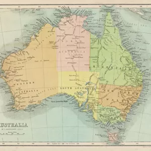
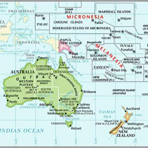
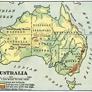
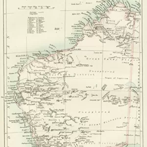
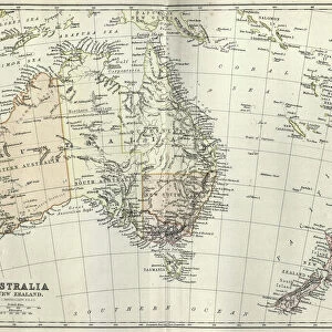
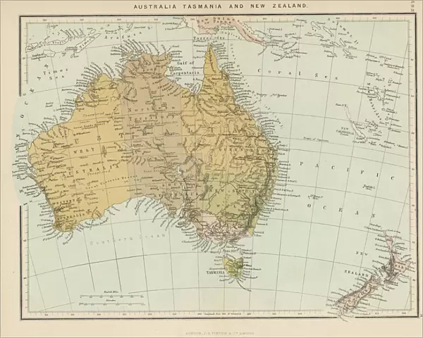
Map showing Australia, Tasmania, New Zealand and neighbouring islands
Mary Evans Picture Library makes available wonderful images created for people to enjoy over the centuries
Media ID 576483
© Mary Evans Picture Library 2015 - https://copyrighthub.org/s0/hub1/creation/maryevans/MaryEvansPictureID/10015338
Maps Neighbouring Tasmania Zealand
16"x20" (51x41cm) Metal Print
Discover the beauty of the South Pacific with our stunning Metal Prints from the Media Storehouse collection, featuring this captivating map image from Mary Evans Picture Library. Explore the intricate details of Australia, Tasmania, New Zealand, and their neighboring islands brought to life in vibrant colors and sharp contrasts on a sleek, durable metal surface. Add a touch of adventure and geography to your home or office decor while creating a unique and eye-catching statement piece.
Made with durable metal and luxurious printing techniques, our metal photo prints go beyond traditional canvases, adding a cool, modern touch to your space. Wall mount on back. Eco-friendly 100% post-consumer recycled ChromaLuxe aluminum surface. The thickness of the print is 0.045". Featuring a Scratch-resistant surface and Rounded corners. Backing hangers are attached to the back of the print and float the print 1/2-inch off the wall when hung, the choice of hanger may vary depending on size and International orders will come with Float Mount hangers only. Finished with a brilliant white high gloss surface for unsurpassed detail and vibrance. Printed using Dye-Sublimation and for best care we recommend a non-ammonia glass cleaner, water, or isopropyl (rubbing) alcohol to prevent harming the print surface. We recommend using a clean, lint-free cloth to wipe off the print. The ultra-hard surface is scratch-resistant, waterproof and weatherproof. Avoid direct sunlight exposure.
Made with durable metal and luxurious printing techniques, metal prints bring images to life and add a modern touch to any space
Estimated Image Size (if not cropped) is 50.8cm x 40.6cm (20" x 16")
Estimated Product Size is 51.4cm x 41.2cm (20.2" x 16.2")
These are individually made so all sizes are approximate
Artwork printed orientated as per the preview above, with landscape (horizontal) orientation to match the source image.
FEATURES IN THESE COLLECTIONS
> Mary Evans Prints Online
> Maps
> Maps and Charts
> Early Maps
> Maps and Charts
> Related Images
> Oceania
> Australia
> Related Images
> Oceania
> New Zealand
> Maps
> Oceania
> New Zealand
> Related Images
EDITORS COMMENTS
1. Title: "Exploring the Pacific: A Historical Map Showcasing Australia, New Zealand, and Neighbouring Islands (circa 1890)" This historical map print, sourced from Mary Evans Picture Library, offers a glimpse into the geographical knowledge of the late 19th century. The map meticulously outlines the vast expanse of the Pacific Ocean, with a particular focus on the regions of Australia, Tasmania, New Zealand, and their neighbouring islands. The map, produced circa 1890, showcases the intricate details of the Australian continent, including its various territories and islands, such as Tasmania. The map also highlights the unique cartographic representation of New Zealand, with its distinctive shapes and labels. The neighbouring islands, including Fiji, Papua New Guinea, and the Solomon Islands, are also depicted, offering a broader perspective of the Pacific region during this era. The map's historical significance lies in its ability to provide insight into the geographical understanding of the Pacific during a time when European exploration and colonization were at their peak. The intricate detail and accuracy of the map are a testament to the cartographic skills of the time. The use of vivid colours and clear labeling makes it an engaging and informative piece for anyone interested in the history of Australia, New Zealand, and the wider Pacific region. Whether used as a decorative piece in a home or office, or as a teaching tool for students, this historical map print is a captivating reminder of the rich history and cultural connections that bind the countries of the Pacific together. In conclusion, this map print from Mary Evans Picture Library is a must-have for anyone with a passion for history, geography, or the Pacific region. Its historical significance, intricate detail, and captivating design make it a valuable addition to any collection.
MADE IN THE USA
Safe Shipping with 30 Day Money Back Guarantee
FREE PERSONALISATION*
We are proud to offer a range of customisation features including Personalised Captions, Color Filters and Picture Zoom Tools
SECURE PAYMENTS
We happily accept a wide range of payment options so you can pay for the things you need in the way that is most convenient for you
* Options may vary by product and licensing agreement. Zoomed Pictures can be adjusted in the Cart.