Metal Print > Europe > United Kingdom > England > London > Towns > Blackwall
Metal Print : Map, Millwall Docks (Harrow Lane) and Poplar, East London
 and Poplar, East London")


![]()
Metal Prints from Mary Evans Picture Library
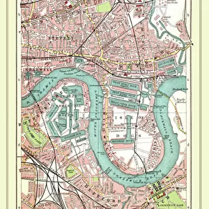
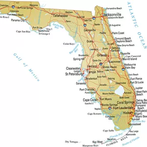
Map, Millwall Docks (Harrow Lane) and Poplar, East London
Map, Millwall Docks (Harrow Lane) and Poplar, East London, with railway lines and links. Date: 1906
Mary Evans Picture Library makes available wonderful images created for people to enjoy over the centuries
Media ID 23106448
© Mary Evans / Pharcide
Basin Blackwall Brunswick Coal Depot Dock Docks Export Harrow Lane Lines Links Maps Millwall Poplar Tunnel Wharf
16"x24" (61x41cm) Metal Print
Step back in time with our stunning Metal Print of Map, Millwall Docks (Harrow Lane) and Poplar, East London, dating back to 1906. This captivating image from Mary Evans Prints Online showcases the intricate details of the historic docks and railway lines, bringing the bustling industrial heart of East London to your home or office. Our high-quality Metal Prints are known for their vibrant colors, brilliant clarity, and long-lasting durability. With a sleek, modern design and a focus on preserving historical detail, this unique print is sure to be a conversation starter and a cherished addition to any space.
Made with durable metal and luxurious printing techniques, our metal photo prints go beyond traditional canvases, adding a cool, modern touch to your space. Wall mount on back. Eco-friendly 100% post-consumer recycled ChromaLuxe aluminum surface. The thickness of the print is 0.045". Featuring a Scratch-resistant surface and Rounded corners. Backing hangers are attached to the back of the print and float the print 1/2-inch off the wall when hung, the choice of hanger may vary depending on size and International orders will come with Float Mount hangers only. Finished with a brilliant white high gloss surface for unsurpassed detail and vibrance. Printed using Dye-Sublimation and for best care we recommend a non-ammonia glass cleaner, water, or isopropyl (rubbing) alcohol to prevent harming the print surface. We recommend using a clean, lint-free cloth to wipe off the print. The ultra-hard surface is scratch-resistant, waterproof and weatherproof. Avoid direct sunlight exposure.
Made with durable metal and luxurious printing techniques, metal prints bring images to life and add a modern touch to any space
Estimated Product Size is 61.5cm x 41.2cm (24.2" x 16.2")
These are individually made so all sizes are approximate
Artwork printed orientated as per the preview above, with landscape (horizontal) orientation to match the source image.
FEATURES IN THESE COLLECTIONS
> Mary Evans Prints Online
> New Images August 2021
> Architecture
> Tunnels
> Arts
> Landscape paintings
> Waterfall and river artworks
> River artworks
> Asia
> India
> Related Images
> Europe
> United Kingdom
> England
> London
> Boroughs
> Harrow
> Europe
> United Kingdom
> England
> London
> River Thames
> Europe
> United Kingdom
> England
> London
> Towns
> Blackwall
> Europe
> United Kingdom
> England
> London
> Towns
> Millwall
> Europe
> United Kingdom
> England
> London
> Towns
> Poplar
> Europe
> United Kingdom
> England
> London
> Transport
> Railway
EDITORS COMMENTS
This photograph print, dated 1906, showcases a bird's-eye view of Map, Millwall Docks (Harrow Lane) and Poplar in East London during the Edwardian era. The intricate network of docks and waterways is a testament to the bustling maritime activity that once thrived in this part of the city. The West India Docks, located at the center of the image, were a major hub for importing and exporting goods from the British colonies. The Basin, with its large, enclosed body of water, is visible at the top left corner of the print. The Thames River, a vital artery for transportation, winds its way through the scene, connecting the docks to the heart of London. The railway lines and links, crisscrossing the landscape, played a crucial role in the efficient movement of goods between the docks and the rest of the country. The Blackwall Tunnel, a railway tunnel under the River Thames, is visible at the bottom right corner of the print. Coal depots and wharfs, such as Brunswick Wharf and Millwall Docks, can be seen along the water's edge. The Map and Harrow Lane Docks, located towards the bottom left of the print, were used primarily for the handling of general cargo. The intricate details of this photograph provide a fascinating glimpse into the past, offering a unique perspective on the transportation infrastructure that once connected London to the world during the early 20th century.
MADE IN THE USA
Safe Shipping with 30 Day Money Back Guarantee
FREE PERSONALISATION*
We are proud to offer a range of customisation features including Personalised Captions, Color Filters and Picture Zoom Tools
SECURE PAYMENTS
We happily accept a wide range of payment options so you can pay for the things you need in the way that is most convenient for you
* Options may vary by product and licensing agreement. Zoomed Pictures can be adjusted in the Cart.