Metal Print > Arts > Artists > M > Gerardus Mercator
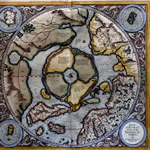
Metal Print : Map of the Americas1633 Date: 1633


Resolution may be reduced at this size (116 DPI)
![]()
Metal Prints from Mary Evans Picture Library
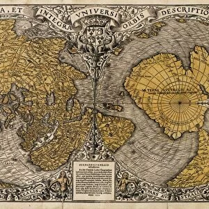
Map of the Americas1633 Date: 1633
Mary Evans Picture Library makes available wonderful images created for people to enjoy over the centuries
Media ID 20184198
© The Pictures Now Image Collection / Bubblepunk
Antiquarian Antique Appears Australis Circle Continent Fills Gerardus Imaginary Journey Journeys Maps Mercator Smaller Spheres Terra Travels Treks Trip Trips Voyage Voyages
16"x20" (51x41cm) Metal Print
Discover history with our stunning Metal Prints from Media Storehouse, featuring the captivating Map of the Americas1633 Date: 1633, available exclusively through Mary Evans Prints Online. This intricately detailed map, dating back to 1633, showcases the early exploration and discovery of the American continents. The vibrant colors and sharp lines pop against the sleek, polished metal surface, making this a unique and eye-catching addition to any home or office decor. Each Metal Print is printed using the highest quality materials, ensuring a long-lasting and durable piece that is sure to impress. Travel back in time and add a touch of history to your space with this beautiful and historic Map of the Americas1633 Date: 1633 Metal Print from Media Storehouse.
Made with durable metal and luxurious printing techniques, our metal photo prints go beyond traditional canvases, adding a cool, modern touch to your space. Wall mount on back. Eco-friendly 100% post-consumer recycled ChromaLuxe aluminum surface. The thickness of the print is 0.045". Featuring a Scratch-resistant surface and Rounded corners. Backing hangers are attached to the back of the print and float the print 1/2-inch off the wall when hung, the choice of hanger may vary depending on size and International orders will come with Float Mount hangers only. Finished with a brilliant white high gloss surface for unsurpassed detail and vibrance. Printed using Dye-Sublimation and for best care we recommend a non-ammonia glass cleaner, water, or isopropyl (rubbing) alcohol to prevent harming the print surface. We recommend using a clean, lint-free cloth to wipe off the print. The ultra-hard surface is scratch-resistant, waterproof and weatherproof. Avoid direct sunlight exposure.
Made with durable metal and luxurious printing techniques, metal prints bring images to life and add a modern touch to any space
Estimated Image Size (if not cropped) is 50.8cm x 40.6cm (20" x 16")
Estimated Product Size is 51.4cm x 41.2cm (20.2" x 16.2")
These are individually made so all sizes are approximate
Artwork printed orientated as per the preview above, with landscape (horizontal) orientation to match the source image.
FEATURES IN THESE COLLECTIONS
> Mary Evans Prints Online
> Pictures Now
> Animals
> Mammals
> Cricetidae
> Australis
> Animals
> Mammals
> Delphinidae
> Australis
> Animals
> Mammals
> Molossidae
> Australis
> Arts
> Artists
> M
> Gerardus Mercator
> Maps and Charts
> Gerardus Mercator's Cartographic
> Maps and Charts
> Related Images
> North America
> United States of America
> Maps
> Popular Themes
> North Island
> South America
> Related Images
EDITORS COMMENTS
This antique map, titled "America" and dated 1633, offers a fascinating glimpse into the early European understanding of the American continents. Created by the renowned cartographer Gerardus Mercator or one of his associates, this map represents a significant moment in the history of cartography. The map, known as "America1633" or "Ofs1633," is a testament to the exploratory spirit of the 17th century. The map's intricate detailing showcases the known lands of the Americas, with North and South America clearly defined, and the Caribbean islands meticulously charted. The map also includes an imaginary southern continent, "Terra Australis," which was believed to balance the hemispheres. The map is particularly noteworthy for its use of two spheres, one for the northern hemisphere and the other for the southern. These spheres serve to highlight the geographical knowledge of the time and the cartographer's efforts to accurately represent the world. The map also features a circle that appears to represent a journey or a series of journeys, possibly indicating significant trade routes or exploratory expeditions. Despite its age, the map remains an impressive piece of cartographic art. Its intricate detailing and accurate representation of known lands make it an invaluable resource for historians, geographers, and anyone interested in the history of exploration. This map transports us back in time, allowing us to imagine the journeys and discoveries that once filled the blank spaces on the map. Whether you're an armchair explorer or a seasoned traveler, this antique map is sure to inspire a sense of wonder and curiosity about the world and its rich history.
MADE IN THE USA
Safe Shipping with 30 Day Money Back Guarantee
FREE PERSONALISATION*
We are proud to offer a range of customisation features including Personalised Captions, Color Filters and Picture Zoom Tools
SECURE PAYMENTS
We happily accept a wide range of payment options so you can pay for the things you need in the way that is most convenient for you
* Options may vary by product and licensing agreement. Zoomed Pictures can be adjusted in the Cart.