Metal Print > Europe > United Kingdom > Scotland > Maps
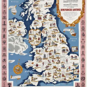
Metal Print : Poster, Map of Royal Britain


![]()
Metal Prints from Mary Evans Picture Library
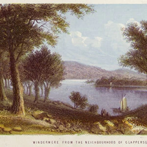
Poster, Map of Royal Britain
Poster, Map of Royal Britain.
1957
Mary Evans Picture Library makes available wonderful images created for people to enjoy over the centuries
Media ID 14412824
© Mary Evans Picture Library/Onslow Auctions Limited
16"x24" (61x41cm) Metal Print
Discover the regal charm of yesteryears with our Media Storehouse Metal Prints featuring the iconic "Map of Royal Britain" from Mary Evans Picture Library/Onslow Auctions Limited. This vintage poster, originally published in 1957, showcases an intricately detailed map of the British monarchy's historic residences, estates, and castles. Each Metal Print is meticulously crafted using high-definition print technology and coated with a protective layer of clear anodized aluminum, ensuring vibrant colors and long-lasting durability. Elevate your home or office décor with this stunning piece of historical art that tells a captivating story of the British monarchy's rich heritage.
Made with durable metal and luxurious printing techniques, our metal photo prints go beyond traditional canvases, adding a cool, modern touch to your space. Wall mount on back. Eco-friendly 100% post-consumer recycled ChromaLuxe aluminum surface. The thickness of the print is 0.045". Featuring a Scratch-resistant surface and Rounded corners. Backing hangers are attached to the back of the print and float the print 1/2-inch off the wall when hung, the choice of hanger may vary depending on size and International orders will come with Float Mount hangers only. Finished with a brilliant white high gloss surface for unsurpassed detail and vibrance. Printed using Dye-Sublimation and for best care we recommend a non-ammonia glass cleaner, water, or isopropyl (rubbing) alcohol to prevent harming the print surface. We recommend using a clean, lint-free cloth to wipe off the print. The ultra-hard surface is scratch-resistant, waterproof and weatherproof. Avoid direct sunlight exposure.
Made with durable metal and luxurious printing techniques, metal prints bring images to life and add a modern touch to any space
Estimated Image Size (if not cropped) is 38.9cm x 61.5cm (15.3" x 24.2")
Estimated Product Size is 41.2cm x 61.5cm (16.2" x 24.2")
These are individually made so all sizes are approximate
Artwork printed orientated as per the preview above, with portrait (vertical) orientation to match the source image.
FEATURES IN THESE COLLECTIONS
> Europe
> Republic of Ireland
> Maps
> Europe
> United Kingdom
> England
> Maps
> Europe
> United Kingdom
> England
> Posters
> Europe
> United Kingdom
> Maps
> Europe
> United Kingdom
> Scotland
> Maps
> Europe
> United Kingdom
> Scotland
> Posters
> Europe
> United Kingdom
> Scotland
> Related Images
> Europe
> United Kingdom
> Wales
> Maps
> Europe
> United Kingdom
> Wales
> Posters
> Europe
> United Kingdom
> Wales
> Related Images
EDITORS COMMENTS
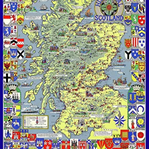
This vibrant and intricately detailed poster, titled "Map of Royal Britain," dates back to 1957 and is a captivating representation of the coats of arms of the monarchs and principalities of England, Wales, Scotland, and Ireland during the 16th through 19th centuries. The map, which is richly colored and adorned with ornate borders, serves as a visual testament to the rich history and complex lineage of the British monarchy. The map is divided into four distinct sections, each representing one of the constituent parts of the United Kingdom. In the English section, the coats of arms of the monarchs from Henry II to Elizabeth II are depicted, while in the Welsh section, the arms of the Princes of Wales and the various Welsh earls and barons are displayed. Scotland's section features the arms of the Scottish monarchs from Malcolm III to Elizabeth II, as well as those of the various Scottish earls and barons. Lastly, the Irish section showcases the arms of the monarchs of Ireland from Henry II to George V, along with those of the various Irish earls and barons. This poster, which measures approximately 23 x 30 inches (58 x 76 cm), is a fascinating historical artifact that provides a visual representation of the complex and interconnected history of the British monarchy. It is a must-have for anyone with an interest in British history, heraldry, or cartography, and is a beautiful and intriguing addition to any home or office decor. The poster, which is in good condition, was originally sold by Onslow Auctions Limited through Mary Evans Prints Online.
MADE IN THE USA
Safe Shipping with 30 Day Money Back Guarantee
FREE PERSONALISATION*
We are proud to offer a range of customisation features including Personalised Captions, Color Filters and Picture Zoom Tools
SECURE PAYMENTS
We happily accept a wide range of payment options so you can pay for the things you need in the way that is most convenient for you
* Options may vary by product and licensing agreement. Zoomed Pictures can be adjusted in the Cart.