Metal Print > Europe > United Kingdom > England > London > Boroughs > Bexley
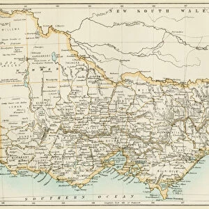
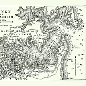
Metal Print : Sydney, Australia - Map of Sydney and Port Jackson


![]()
Metal Prints from Mary Evans Picture Library
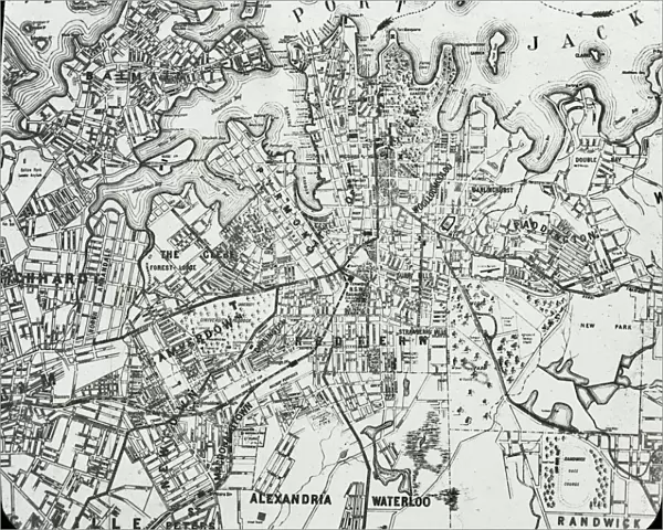
Sydney, Australia - Map of Sydney and Port Jackson
Slide showing a map of Sydney and Port Jackson, with the areas of the city labelled.. Boswell Collection. Slide number 5. Sydney is the most populous city in Australia and the state capital of New South Wales. It is located on Australias south-east coast of the Tasman Sea. Date: circa 1890s
Mary Evans Picture Library makes available wonderful images created for people to enjoy over the centuries
Media ID 14172966
© The Boswell Collection, Bexley Heritage Trust / Mary Evans
Areas Australian Capital Jackson Labelled Slides Sydney
16"x20" (51x41cm) Metal Print
Discover the beauty of Sydney, Australia with our stunning Metal Prints from Media Storehouse. Featuring the iconic Map of Sydney and Port Jackson by Rights Managed from Mary Evans Prints Online, this captivating design showcases the city's landmarks and key areas, including Circular Quay, Darling Harbour, and the famous Port Jackson. Bring a piece of the vibrant and culturally rich city into your home or office with this high-quality Metal Print, perfect for adding a unique and modern touch to any space. The sleek and durable metal material enhances the vivid colors and details of the map, ensuring a long-lasting and eye-catching display. Experience the essence of Sydney every day with this beautiful and functional artwork.
Made with durable metal and luxurious printing techniques, our metal photo prints go beyond traditional canvases, adding a cool, modern touch to your space. Wall mount on back. Eco-friendly 100% post-consumer recycled ChromaLuxe aluminum surface. The thickness of the print is 0.045". Featuring a Scratch-resistant surface and Rounded corners. Backing hangers are attached to the back of the print and float the print 1/2-inch off the wall when hung, the choice of hanger may vary depending on size and International orders will come with Float Mount hangers only. Finished with a brilliant white high gloss surface for unsurpassed detail and vibrance. Printed using Dye-Sublimation and for best care we recommend a non-ammonia glass cleaner, water, or isopropyl (rubbing) alcohol to prevent harming the print surface. We recommend using a clean, lint-free cloth to wipe off the print. The ultra-hard surface is scratch-resistant, waterproof and weatherproof. Avoid direct sunlight exposure.
Made with durable metal and luxurious printing techniques, metal prints bring images to life and add a modern touch to any space
Estimated Image Size (if not cropped) is 50.8cm x 40.6cm (20" x 16")
Estimated Product Size is 51.4cm x 41.2cm (20.2" x 16.2")
These are individually made so all sizes are approximate
Artwork printed orientated as per the preview above, with landscape (horizontal) orientation to match the source image.
FEATURES IN THESE COLLECTIONS
> Europe
> United Kingdom
> England
> London
> Boroughs
> Bexley
> Europe
> United Kingdom
> Wales
> Maps
> Europe
> United Kingdom
> Wales
> Posters
> Europe
> United Kingdom
> Wales
> Related Images
> Maps and Charts
> Early Maps
> Maps and Charts
> Related Images
> Maps and Charts
> Wales
EDITORS COMMENTS
This lantern slide presents a detailed map of Sydney, Australia, and Port Jackson from the late 19th century. Dating back to approximately the 1890s, this map is an essential historical record of the city during a pivotal period in its development. Sydney, the most populous city in Australia and the capital of New South Wales, is situated on the south-east coast of the Tasman Sea. The map meticulously outlines the various areas of the city, including Circular Quay, The Rocks, Darling Harbour, and Balmain. Port Jackson, the natural harbor that cradles Sydney, is also clearly marked on the map. The harbor's strategic location and abundant resources played a significant role in Sydney's growth as a major trading hub and naval base. The map also reveals the city's early urban planning, with the grid-like street layout and the presence of parks and public spaces. This exquisite slide is part of the Boswell Collection, slide number 5, and serves as a fascinating glimpse into the history of Sydney during the late 19th century. The intricate details of the map offer valuable insights into the city's geography, infrastructure, and development during this period. As you explore the labeled areas, you can almost hear the bustling sounds of the busy port and the lively energy of Sydney's early inhabitants. This historical artifact invites us to delve deeper into the rich history of one of the world's most beloved and vibrant cities.
MADE IN THE USA
Safe Shipping with 30 Day Money Back Guarantee
FREE PERSONALISATION*
We are proud to offer a range of customisation features including Personalised Captions, Color Filters and Picture Zoom Tools
SECURE PAYMENTS
We happily accept a wide range of payment options so you can pay for the things you need in the way that is most convenient for you
* Options may vary by product and licensing agreement. Zoomed Pictures can be adjusted in the Cart.