Metal Print > Africa > Related Images
Metal Print : Telegraph map of Upper Egypt


![]()
Metal Prints from Mary Evans Picture Library
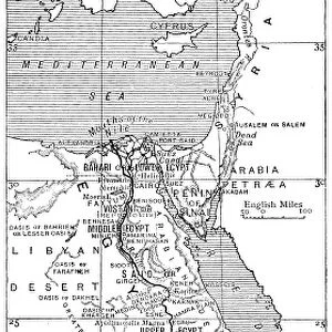
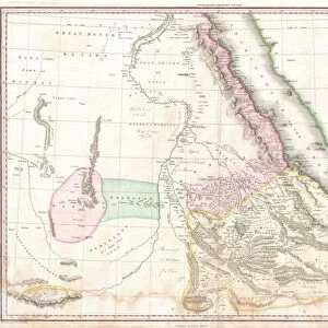
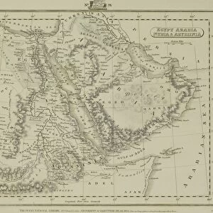
Telegraph map of Upper Egypt
Telegraph map of Upper Egypt 1882, compiled by the Intelligence Branch, War Office; scale 1:4 000 000; one of five maps, probably belonging to Capt George Frederick Wilson, Royal Engineers, Superintendent of Works on the Sudan Military Railway during the 1st Sudan War, 1884-1885. Date: 1882
Mary Evans Picture Library makes available wonderful images created for people to enjoy over the centuries
Media ID 14390202
© The National Army Museum / Mary Evans Picture Library
1882 Compiled Corps Engineering Engineers Intelligence Maps Office Scale Sudan Telegraph Upper
16"x20" (51x41cm) Metal Print
Discover the rich history of Upper Egypt with our stunning Metal Prints from Media Storehouse. This exquisite piece features a rare and captivating Telegraph map of Upper Egypt from 1882, compiled by the Intelligence Branch, War Office. With intricate details and authenticity, this map transports you back in time, providing a unique and educational addition to your home or office decor. Printed on high-quality metal sheets using state-of-the-art technology, each Metal Print is waterproof, scratch-resistant, and UV-protected, ensuring long-lasting beauty and durability. Elevate your space with a piece of history that is sure to inspire and captivate.
Made with durable metal and luxurious printing techniques, our metal photo prints go beyond traditional canvases, adding a cool, modern touch to your space. Wall mount on back. Eco-friendly 100% post-consumer recycled ChromaLuxe aluminum surface. The thickness of the print is 0.045". Featuring a Scratch-resistant surface and Rounded corners. Backing hangers are attached to the back of the print and float the print 1/2-inch off the wall when hung, the choice of hanger may vary depending on size and International orders will come with Float Mount hangers only. Finished with a brilliant white high gloss surface for unsurpassed detail and vibrance. Printed using Dye-Sublimation and for best care we recommend a non-ammonia glass cleaner, water, or isopropyl (rubbing) alcohol to prevent harming the print surface. We recommend using a clean, lint-free cloth to wipe off the print. The ultra-hard surface is scratch-resistant, waterproof and weatherproof. Avoid direct sunlight exposure.
Made with durable metal and luxurious printing techniques, metal prints bring images to life and add a modern touch to any space
Estimated Image Size (if not cropped) is 40.6cm x 50.8cm (16" x 20")
Estimated Product Size is 41.2cm x 51.4cm (16.2" x 20.2")
These are individually made so all sizes are approximate
Artwork printed orientated as per the preview above, with portrait (vertical) orientation to match the source image.
EDITORS COMMENTS
This historic print depicts the Telegraph Map of Upper Egypt, compiled by the Intelligence Branch of the War Office in 1882. The map, which has a scale of 1:4,000,000, is one of five maps that likely belonged to Captain George Frederick Wilson, Royal Engineers, who served as the Superintendent of Works on the Sudan Military Railway during the First Sudan War from 1884 to 1885. The map provides a detailed and accurate representation of Upper Egypt during a pivotal period in its history. The map is an essential record of the geography and infrastructure of Upper Egypt at the time, with an emphasis on the telegraph lines that were crucial for communication and coordination during military campaigns. The map's intricate detailing of the Nile River, its tributaries, and the various settlements along its banks is a testament to the surveying skills of the Royal Engineers. The First Sudan War, also known as the Mahdist War, was a significant conflict in the history of Egypt and the Sudan. The war began in 1881 when a Muslim religious and political movement, led by Muhammad Ahmad, challenged the rule of the Egyptian Khedive Tawfiq and the Ottoman Empire. The conflict lasted until 1885 and resulted in the establishment of the Mahdist State in Sudan. Captain Wilson's maps played a crucial role in the military efforts during the war. The maps provided essential information for the planning and execution of military campaigns, the construction of the Sudan Military Railway, and the establishment of telegraph communication lines. The map's historical significance lies not only in its role during the war but also in its value as a primary source for understanding the geography and infrastructure of Upper Egypt during this period.
MADE IN THE USA
Safe Shipping with 30 Day Money Back Guarantee
FREE PERSONALISATION*
We are proud to offer a range of customisation features including Personalised Captions, Color Filters and Picture Zoom Tools
SECURE PAYMENTS
We happily accept a wide range of payment options so you can pay for the things you need in the way that is most convenient for you
* Options may vary by product and licensing agreement. Zoomed Pictures can be adjusted in the Cart.