Metal Print > Europe > United Kingdom > Wales > Maps
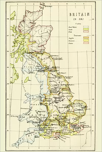
Metal Print : Map of Britain in 597 AD

Metal Prints from North Wind
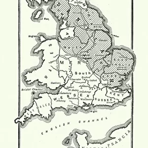
Map of Britain in 597 AD
Map of territory controlled by Celts, Picts, Anglos, Saxons, and other tribes in Britain in 597 AD.
Printed color lithograph of a 19th-century illustration
North Wind Picture Archives brings history to life with stock images and hand-colored illustrations
Media ID 5877819
© North Wind Picture Archives
500s 6th Century Ancient Britain British Isles England Great Britain Medieval Middle Ages Scot Land Territory Tribe Wales Britannica Celts Picts Saxons
16"x24" (61x41cm) Metal Print
Step back in time with our stunning Media Storehouse Metal Print of the Map of Britain in 597 AD from North Wind Picture Archives. This captivating illustration depicts the territories controlled by the Celts, Picts, Anglos, Saxons, and other tribes in Britain during this historical period. Printed using color lithography on high-quality metal, this artwork beautifully preserves the intricate details of the 19th-century map. Bring history to life in your home or office with this unique and eye-catching addition to your decor.
Made with durable metal and luxurious printing techniques, our metal photo prints go beyond traditional canvases, adding a cool, modern touch to your space. Wall mount on back. Eco-friendly 100% post-consumer recycled ChromaLuxe aluminum surface. The thickness of the print is 0.045". Featuring a Scratch-resistant surface and Rounded corners. Backing hangers are attached to the back of the print and float the print 1/2-inch off the wall when hung, the choice of hanger may vary depending on size and International orders will come with Float Mount hangers only. Finished with a brilliant white high gloss surface for unsurpassed detail and vibrance. Printed using Dye-Sublimation and for best care we recommend a non-ammonia glass cleaner, water, or isopropyl (rubbing) alcohol to prevent harming the print surface. We recommend using a clean, lint-free cloth to wipe off the print. The ultra-hard surface is scratch-resistant, waterproof and weatherproof. Avoid direct sunlight exposure.
Made with durable metal and luxurious printing techniques, metal prints bring images to life and add a modern touch to any space
Estimated Image Size (if not cropped) is 37.5cm x 61.5cm (14.8" x 24.2")
Estimated Product Size is 41.2cm x 61.5cm (16.2" x 24.2")
These are individually made so all sizes are approximate
Artwork printed orientated as per the preview above, with portrait (vertical) orientation to match the source image.
FEATURES IN THESE COLLECTIONS
> Arts
> Art Movements
> Medieval Art
> Europe
> France
> Canton
> Landes
> Europe
> United Kingdom
> England
> Maps
> Europe
> United Kingdom
> Wales
> Maps
> Europe
> United Kingdom
> Wales
> Posters
> Europe
> United Kingdom
> Wales
> Related Images
> Maps and Charts
> Early Maps
> Maps and Charts
> Related Images
> Maps and Charts
> Wales
> North Wind Picture Archives
> Ancient history
> North Wind Picture Archives
> Maps
EDITORS COMMENTS
This vintage print showcases a detailed map of Britain in the year 597 AD, providing a glimpse into the complex tapestry of tribes and territories that once defined this ancient land. The printed color lithograph, derived from a 19th-century illustration, beautifully captures the essence of medieval art and history. As we delve into this remarkable depiction, we can discern the various groups that held sway over different regions during this era. From the Celts to the Picts, Anglos to Saxons, and numerous other tribes scattered across Britain's landscape – each left their indelible mark on its history. The map not only highlights territorial divisions but also invites us to explore Wales, England, Scotland, and beyond. It serves as an invaluable resource for historians and enthusiasts alike seeking insights into British Isles' past during the 6th century. Transporting us back in time through its intricate details and artistic flair, this print offers a fascinating window into an age when power dynamics were constantly shifting amidst political intrigue. It reminds us of how far Great Britain has come since those early days while honoring its rich heritage rooted in these ancient times. Whether you are captivated by historical maps or simply appreciate art from bygone eras like the Middle Ages - this exquisite print is sure to ignite your imagination with tales of conquests won and lost within Britannica's shores.
MADE IN THE USA
Safe Shipping with 30 Day Money Back Guarantee
FREE PERSONALISATION*
We are proud to offer a range of customisation features including Personalised Captions, Color Filters and Picture Zoom Tools
SECURE PAYMENTS
We happily accept a wide range of payment options so you can pay for the things you need in the way that is most convenient for you
* Options may vary by product and licensing agreement. Zoomed Pictures can be adjusted in the Cart.