Metal Print > Arts > Artists > O > Oceanic Oceanic
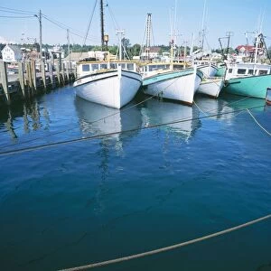
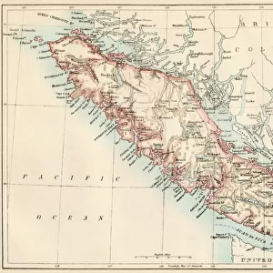
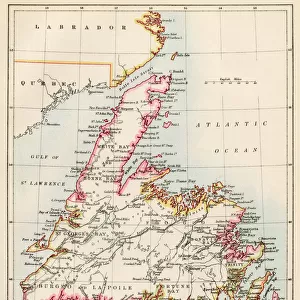
Metal Print : New Brunswick and Nova Scotia, 1870s


![]()
Metal Prints from North Wind
New Brunswick and Nova Scotia, 1870s
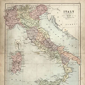
Map of Nova Scotia, Prince Edward Island, and New Brunswick, 1870s.
Printed color lithograph
North Wind Picture Archives brings history to life with stock images and hand-colored illustrations
Media ID 5879743
© North Wind Picture Archives
1870s Atlantic Coast Atlantic Ocean Canada Canadian Island Maritime Provinces Nova Scotia Bay Of Fundy Maritimes New Brunswick Prince Edward Island
16"x20" (51x41cm) Metal Print
Step back in time with our stunning Media Storehouse Metal Print featuring a captivating image of Nova Scotia, Prince Edward Island, and New Brunswick from the North Wind Picture Archives, dated back to the 1870s. This vintage map, printed in vibrant colors through the lithograph process, showcases the historical landscape of the Maritime provinces during an era of great change. The high-quality metal print not only preserves the intricate details of the map but also adds a modern and sleek touch to your home or office décor. Transport yourself to the past with this beautiful and unique piece of Canadian history.
Made with durable metal and luxurious printing techniques, our metal photo prints go beyond traditional canvases, adding a cool, modern touch to your space. Wall mount on back. Eco-friendly 100% post-consumer recycled ChromaLuxe aluminum surface. The thickness of the print is 0.045". Featuring a Scratch-resistant surface and Rounded corners. Backing hangers are attached to the back of the print and float the print 1/2-inch off the wall when hung, the choice of hanger may vary depending on size and International orders will come with Float Mount hangers only. Finished with a brilliant white high gloss surface for unsurpassed detail and vibrance. Printed using Dye-Sublimation and for best care we recommend a non-ammonia glass cleaner, water, or isopropyl (rubbing) alcohol to prevent harming the print surface. We recommend using a clean, lint-free cloth to wipe off the print. The ultra-hard surface is scratch-resistant, waterproof and weatherproof. Avoid direct sunlight exposure.
Made with durable metal and luxurious printing techniques, metal prints bring images to life and add a modern touch to any space
Estimated Image Size (if not cropped) is 50.8cm x 40.6cm (20" x 16")
Estimated Product Size is 51.4cm x 41.2cm (20.2" x 16.2")
These are individually made so all sizes are approximate
Artwork printed orientated as per the preview above, with landscape (horizontal) orientation to match the source image.
FEATURES IN THESE COLLECTIONS
> Arts
> Artists
> O
> Oceanic Oceanic
> Maps and Charts
> Related Images
> North America
> Canada
> Maps
> North America
> Canada
> Related Images
> North America
> Related Images
> Popular Themes
> North Island
> North Wind Picture Archives
> Canadian history
> North Wind Picture Archives
> Maps
EDITORS COMMENTS
This vintage print takes us back to the 1870s, offering a glimpse into the rich history and heritage of Canada's Maritime Provinces. The beautifully detailed map showcases the enchanting landscapes of New Brunswick, Nova Scotia, and Prince Edward Island, capturing the essence of this bygone era. As we study this illustration, we are transported to a time when traditional cartography was an art form in itself. The vibrant printed colors bring life to each province's unique features: from the rugged Atlantic coastlines that meet the vastness of the ocean to the intricate network of rivers and bays that crisscross these lands. The significance of this piece lies not only in its artistic value but also in its historical importance. It serves as a window into North America's past, allowing us to trace how these provinces were shaped over time. From Bay of Fundy's powerful tides to Prince Edward Island's charming island landscape, every detail on this map tells a story waiting to be discovered. Whether you have roots in these regions or simply appreciate their beauty and cultural significance, this print is sure to captivate your imagination. It stands as a testament to our connection with nature and our desire for exploration – reminding us that even within modernity lies a deep appreciation for our roots and traditions.
MADE IN THE USA
Safe Shipping with 30 Day Money Back Guarantee
FREE PERSONALISATION*
We are proud to offer a range of customisation features including Personalised Captions, Color Filters and Picture Zoom Tools
SECURE PAYMENTS
We happily accept a wide range of payment options so you can pay for the things you need in the way that is most convenient for you
* Options may vary by product and licensing agreement. Zoomed Pictures can be adjusted in the Cart.