Metal Print > Arts > Artists > O > Oceanic Oceanic
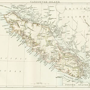
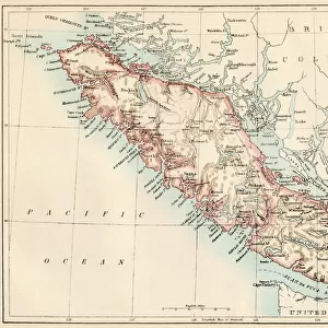
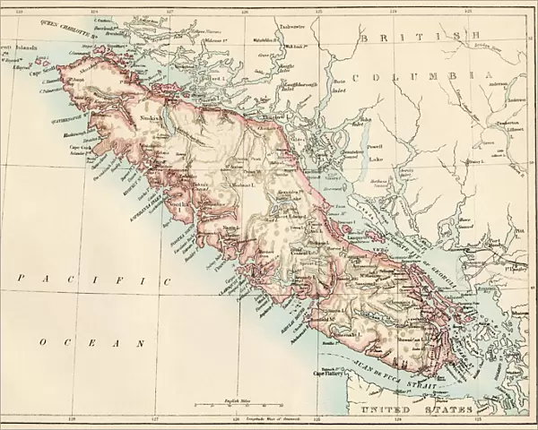
Metal Print : Vancouver Island map, 1870s


Metal Prints from North Wind
Vancouver Island map, 1870s
Map of Vancouver Island, British Columbia, Canada, 1870s.
Lithograph reproduction of a 19th-century illustration
North Wind Picture Archives brings history to life with stock images and hand-colored illustrations
Media ID 5879572
© North Wind Picture Archives
1870s 1880s British Columbia Canada Canadian Island Pacific Pacific Coast Pacific Northwest Pacific Ocean Strait Juan De Fuca Strait Puget Sound Vancouver Vancouver Island
16"x20" (51x41cm) Metal Print
Discover the rich history of Vancouver Island with our stunning Metal Print of a vintage map from the North Wind Picture Archives. This captivating 1870s lithograph reproduction transports you back in time, showcasing the intricate details of British Columbia, Canada's Vancouver Island during an era of exploration and discovery. The high-quality Metal Print brings the map to life with vibrant colors and exceptional clarity, making it a beautiful addition to any home or office. Preserve history and add a touch of timeless charm to your space with our Vancouver Island Map Metal Print.
Made with durable metal and luxurious printing techniques, our metal photo prints go beyond traditional canvases, adding a cool, modern touch to your space. Wall mount on back. Eco-friendly 100% post-consumer recycled ChromaLuxe aluminum surface. The thickness of the print is 0.045". Featuring a Scratch-resistant surface and Rounded corners. Backing hangers are attached to the back of the print and float the print 1/2-inch off the wall when hung, the choice of hanger may vary depending on size and International orders will come with Float Mount hangers only. Finished with a brilliant white high gloss surface for unsurpassed detail and vibrance. Printed using Dye-Sublimation and for best care we recommend a non-ammonia glass cleaner, water, or isopropyl (rubbing) alcohol to prevent harming the print surface. We recommend using a clean, lint-free cloth to wipe off the print. The ultra-hard surface is scratch-resistant, waterproof and weatherproof. Avoid direct sunlight exposure.
Made with durable metal and luxurious printing techniques, metal prints bring images to life and add a modern touch to any space
Estimated Image Size (if not cropped) is 50.8cm x 40.6cm (20" x 16")
Estimated Product Size is 51.4cm x 41.2cm (20.2" x 16.2")
These are individually made so all sizes are approximate
Artwork printed orientated as per the preview above, with landscape (horizontal) orientation to match the source image.
FEATURES IN THESE COLLECTIONS
> Arts
> Artists
> O
> Oceanic Oceanic
> Maps and Charts
> Related Images
> North America
> Canada
> Maps
> North America
> Canada
> Related Images
> North America
> Canada
> Vancouver
> North America
> Related Images
> Popular Themes
> North Island
> North Wind Picture Archives
> Canadian history
> North Wind Picture Archives
> Maps
EDITORS COMMENTS
This lithograph reproduction takes us back to the 1870s, offering a glimpse into the rich history and heritage of Vancouver Island, British Columbia. The vintage map showcases the island's intricate details with remarkable precision and artistry. As we explore this piece of traditional artwork, our eyes are immediately drawn to the majestic Pacific Ocean that surrounds Vancouver Island. The map highlights its strategic location along the Pacific Coast, nestled between Juan de Fuca Strait and Puget Sound. The illustration beautifully captures the essence of this Canadian gem, depicting its lush landscapes, charming towns, and bustling ports. It serves as a testament to the island's significance during this era when it was rapidly developing as an important hub in North America. Every stroke on this historic map tells a story – from early settlements to indigenous territories – providing us with invaluable insights into how Vancouver Island evolved over time. This print is not just a visual delight; it is also an educational tool that allows us to delve deeper into Canada's past. Whether you are an art enthusiast or a history buff, this exquisite 19th-century lithograph offers a window into bygone days. It invites you on a journey through time while celebrating the natural beauty and cultural heritage of Vancouver Island – truly capturing its spirit for generations to come.
MADE IN THE USA
Safe Shipping with 30 Day Money Back Guarantee
FREE PERSONALISATION*
We are proud to offer a range of customisation features including Personalised Captions, Color Filters and Picture Zoom Tools
SECURE PAYMENTS
We happily accept a wide range of payment options so you can pay for the things you need in the way that is most convenient for you
* Options may vary by product and licensing agreement. Zoomed Pictures can be adjusted in the Cart.