Metal Print > Europe > Italy > Puglia > Andria
Metal Print : Detail of 16th century map of Liguria


![]()
Metal Prints from Science Photo Library
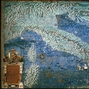
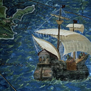
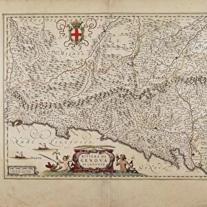
Detail of 16th century map of Liguria
Detail of 16th century map of Liguria. Detail from the map of Liguria, from Porto Venere (far left) to Cervo (far right), showing Genoa (middle), the water courses and the Apennine mountains (labelled). This map of Liguria is contained in the Gallery of Maps in the Vatican Museums. On the left is Andria Dorias Brigatine. Andrea Doria (1466/68-1560) was a sixteenth century Italian admiral and statesman from an ancient family, prominent in Genoa at the time. The Gallery of Maps holds maps which were commissioned between 1578 and 1580 to show the regions of Italy and territories of the church. The maps are based on the work of Ignazio Danti, a 16th century Italian priest, mathematician, astronomer and cosmographer, and are an important record of 16th century geography
Science Photo Library features Science and Medical images including photos and illustrations
Media ID 6350179
© SHEILA TERRY/SCIENCE PHOTO LIBRARY
1500s 16th Century Ancient Atlas Cartography Coast Coastal Diagram Drawing Earth Science Gallery Of Maps Ignazio Danti Italian Italy Mapping Maps Maritime Mediterranean Mountain Mountains Nautical River Rivers Sciences Ship Shipping Ships Sixteenth Century Vatican Museum Vatican Museums Apennine Mountains Apennines Brig Cervo Genoa Genoese Genova Liguria
16"x24" (61x41cm) Metal Print
Discover history in a new light with Media Storehouse Metal Prints. This captivating image showcases a detailed section of a 16th century map of Liguria, taken from the Science Photo Library. From the rugged cliffs of Porto Venere to the charming town of Cervo, this exquisite print highlights the intricate details of the map, including the prominent city of Genoa. Bring history into your home or office with our high-quality Metal Prints, which showcase vibrant colors and stunning detail, making this a truly unique and conversation-starting addition to any space.
Made with durable metal and luxurious printing techniques, our metal photo prints go beyond traditional canvases, adding a cool, modern touch to your space. Wall mount on back. Eco-friendly 100% post-consumer recycled ChromaLuxe aluminum surface. The thickness of the print is 0.045". Featuring a Scratch-resistant surface and Rounded corners. Backing hangers are attached to the back of the print and float the print 1/2-inch off the wall when hung, the choice of hanger may vary depending on size and International orders will come with Float Mount hangers only. Finished with a brilliant white high gloss surface for unsurpassed detail and vibrance. Printed using Dye-Sublimation and for best care we recommend a non-ammonia glass cleaner, water, or isopropyl (rubbing) alcohol to prevent harming the print surface. We recommend using a clean, lint-free cloth to wipe off the print. The ultra-hard surface is scratch-resistant, waterproof and weatherproof. Avoid direct sunlight exposure.
Made with durable metal and luxurious printing techniques, metal prints bring images to life and add a modern touch to any space
Estimated Product Size is 61.5cm x 41.2cm (24.2" x 16.2")
These are individually made so all sizes are approximate
Artwork printed orientated as per the preview above, with landscape (horizontal) orientation to match the source image.
FEATURES IN THESE COLLECTIONS
> Animals
> Mammals
> Muridae
> Water Mouse
> Arts
> Artists
> O
> Oceanic Oceanic
> Arts
> Landscape paintings
> Waterfall and river artworks
> River artworks
> Europe
> Italy
> Liguria
> Genoa
> Europe
> Italy
> Liguria
> Related Images
> Europe
> Italy
> Puglia
> Andria
> Maps and Charts
> Early Maps
EDITORS COMMENTS
This print showcases a mesmerizing detail of a 16th century map of Liguria, an enchanting region in Italy. The map, housed in the prestigious Gallery of Maps at the Vatican Museums, spans from Porto Venere to Cervo and encompasses Genoa at its heart. It intricately depicts the water courses and majestic Apennine mountains that grace this coastal landscape. Adding historical significance to this artwork is the presence of Andrea Doria's Brigatine on the left side. Andrea Doria, a renowned Italian admiral and statesman from an ancient Genoese family, played a pivotal role during the 16th century. Commissioned between 1578 and 1580 by Ignazio Danti, an accomplished Italian priest, mathematician, astronomer, and cosmographer; these maps provide invaluable insights into the geography of that era. They serve as vital records documenting how people perceived their world during this period. The image transports us back in time with its intricate illustration reminiscent of maritime exploration. It evokes feelings of wonderment as we contemplate how sailors navigated through these waters centuries ago. With its rich historical context and artistic beauty, this print serves as both an educational resource for earth sciences enthusiasts and a stunning piece of art for admirers worldwide.
MADE IN THE USA
Safe Shipping with 30 Day Money Back Guarantee
FREE PERSONALISATION*
We are proud to offer a range of customisation features including Personalised Captions, Color Filters and Picture Zoom Tools
SECURE PAYMENTS
We happily accept a wide range of payment options so you can pay for the things you need in the way that is most convenient for you
* Options may vary by product and licensing agreement. Zoomed Pictures can be adjusted in the Cart.