Metal Print > Africa > Related Images
Metal Print : Map of the world, 1590


![]()
Metal Prints from Science Photo Library
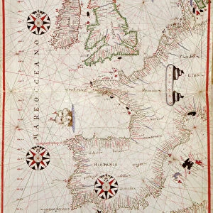
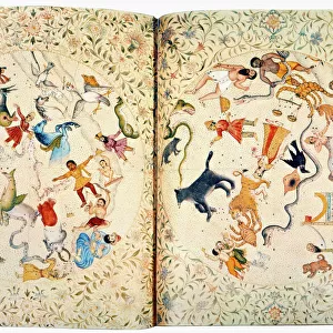
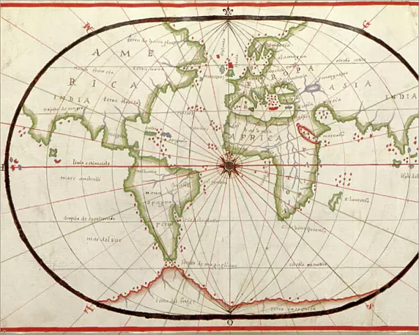
Map of the world, 1590
16th century map of the world. Published around 1590, this map shows the known world, including the new lands being discovered by Europeans exploring across the Atlantic and far to the East around Africa. It forms part of a portolan atlas (a collection of navigational charts) by the cartographer Joan Oliva, who was active from 1580- 1615. A central compass rose lies at the meeting point of the Greenwich Meridian and the equator, and lines of longitude are seen radiating from the poles. Although the land shapes are distorted, and the map incorrectly shows southern Asia attached to North America (far left), maps like this were among the best available at the time
Science Photo Library features Science and Medical images including photos and illustrations
Media ID 1699829
© LIBRARY OF CONGRESS, GEOGRAPHY AND MAP DIVISION/SCIENCE PHOTO LIBRARY
1500s 16th Century Age Of Discovery Cartography Colonies Colony Continent Continental Continents Dutch Empire Eurasian Exploration French Medieval Middle Ages New World North American Old World South America South American Spanish World 1590
16"x20" (51x41cm) Metal Print
Discover the wonders of the past with our Media Storehouse Metal Prints featuring the captivating 1590 Map of the World from Science Photo Library. This intricately detailed 16th-century map showcases the known world as it was understood during the age of exploration, with new lands being discovered beyond the Atlantic. Each Metal Print is meticulously crafted, bringing the rich history and vibrant colors of this iconic map to life. Transform your space into a captivating journey through time with this stunning addition to your decor.
Made with durable metal and luxurious printing techniques, our metal photo prints go beyond traditional canvases, adding a cool, modern touch to your space. Wall mount on back. Eco-friendly 100% post-consumer recycled ChromaLuxe aluminum surface. The thickness of the print is 0.045". Featuring a Scratch-resistant surface and Rounded corners. Backing hangers are attached to the back of the print and float the print 1/2-inch off the wall when hung, the choice of hanger may vary depending on size and International orders will come with Float Mount hangers only. Finished with a brilliant white high gloss surface for unsurpassed detail and vibrance. Printed using Dye-Sublimation and for best care we recommend a non-ammonia glass cleaner, water, or isopropyl (rubbing) alcohol to prevent harming the print surface. We recommend using a clean, lint-free cloth to wipe off the print. The ultra-hard surface is scratch-resistant, waterproof and weatherproof. Avoid direct sunlight exposure.
Made with durable metal and luxurious printing techniques, metal prints bring images to life and add a modern touch to any space
Estimated Image Size (if not cropped) is 50.8cm x 40.6cm (20" x 16")
Estimated Product Size is 51.4cm x 41.2cm (20.2" x 16.2")
These are individually made so all sizes are approximate
Artwork printed orientated as per the preview above, with landscape (horizontal) orientation to match the source image.
FEATURES IN THESE COLLECTIONS
> Africa
> Related Images
> Africa
> South Africa
> Maps
> Africa
> South Africa
> Related Images
> Arts
> Art Movements
> Medieval Art
> Asia
> East Timor
> Maps
> Asia
> East Timor
> Related Images
> Asia
> Related Images
> Europe
> France
> Canton
> Landes
> Science Photo Library
> History
EDITORS COMMENTS
This 16th-century map of the world, published around 1590, offers a glimpse into the expanding horizons of European exploration during the Age of Discovery. Created by esteemed cartographer Joan Oliva, this print showcases the known world at that time, including newly discovered lands across the Atlantic and far to the East around Africa. Part of a portolan atlas, this collection of navigational charts was invaluable for sailors venturing into uncharted territories. At its center lies a prominent compass rose where the Greenwich Meridian intersects with the equator. Radiating lines of longitude extend from both poles, aiding in navigation across vast oceans. While some land shapes may appear distorted and inaccuracies are evident – such as southern Asia mistakenly attached to North America on the far left – it is important to remember that maps like these were among the most advanced tools available during this era. This historical artifact provides insight into colonialism and geographical knowledge prevalent in Dutch society at that time. It reflects an era when empires vied for dominance over new territories and trade routes expanded rapidly. As we examine this fascinating piece from Science Photo Library's archives, let us appreciate how our understanding of geography has evolved since then while acknowledging its significance in shaping our collective history.
MADE IN THE USA
Safe Shipping with 30 Day Money Back Guarantee
FREE PERSONALISATION*
We are proud to offer a range of customisation features including Personalised Captions, Color Filters and Picture Zoom Tools
SECURE PAYMENTS
We happily accept a wide range of payment options so you can pay for the things you need in the way that is most convenient for you
* Options may vary by product and licensing agreement. Zoomed Pictures can be adjusted in the Cart.