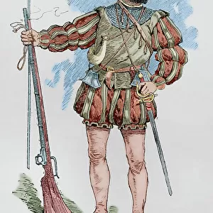
Metal Print > Arts > Artists > Albrecht Durer > Woodcuts
Metal Print : Durers world map, 1515


![]()
Metal Prints from Science Photo Library
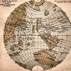
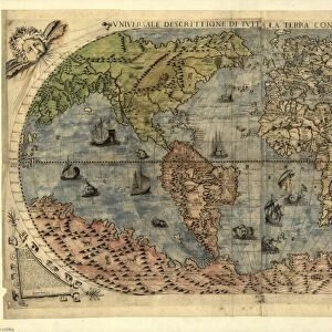
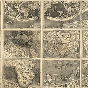
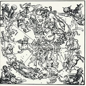
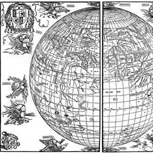
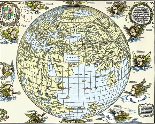
Durers world map, 1515
Durers world map, 1515. Albrecht Durer (1471- 1528) was a German artist. His skillful use of perspective and mathematical proportions made him one of the outstanding artistic figures of the early 16th century. This world map is based on Ptolemys map plus extensions from Behaims Globe of 1492. It is the first known perspective drawing of the entire Earth as a sphere, and was published in 1515, using the best maps of the time in collaboration with Nuremberg astronomer Johann Stabius. The map shows the world surrounded by 12 wind gods. Taken from Dr Willi Kurths The Complete Woodcuts of Albrecht Durer (1936)
Science Photo Library features Science and Medical images including photos and illustrations
Media ID 6351281
© SHEILA TERRY/SCIENCE PHOTO LIBRARY
1500s 1515 16th Century Albrecht Durer Ancient Atlas Cartography Discovery Dr Willi Kurth Earth Science Exploration Globe Journey Knowledge Mapping Maps Renaissance Sciences Sphere Travel Wood Cut
16"x20" (51x41cm) Metal Print
Experience the historical masterpiece of Albrecht Durer's "World Map," created in 1515, brought to life with our Media Storehouse Metal Prints. This exquisite piece of art showcases Durer's unparalleled skill in perspective and mathematical proportions. Each Metal Print is meticulously crafted using premium materials and high-definition printing techniques to ensure vibrant colors and exceptional detail. Transform your space with this captivating piece of art history that is sure to inspire and intrigue. Order your Durer's World Map Metal Print today and bring a piece of the past into your modern world.
Made with durable metal and luxurious printing techniques, our metal photo prints go beyond traditional canvases, adding a cool, modern touch to your space. Wall mount on back. Eco-friendly 100% post-consumer recycled ChromaLuxe aluminum surface. The thickness of the print is 0.045". Featuring a Scratch-resistant surface and Rounded corners. Backing hangers are attached to the back of the print and float the print 1/2-inch off the wall when hung, the choice of hanger may vary depending on size and International orders will come with Float Mount hangers only. Finished with a brilliant white high gloss surface for unsurpassed detail and vibrance. Printed using Dye-Sublimation and for best care we recommend a non-ammonia glass cleaner, water, or isopropyl (rubbing) alcohol to prevent harming the print surface. We recommend using a clean, lint-free cloth to wipe off the print. The ultra-hard surface is scratch-resistant, waterproof and weatherproof. Avoid direct sunlight exposure.
Made with durable metal and luxurious printing techniques, metal prints bring images to life and add a modern touch to any space
Estimated Image Size (if not cropped) is 50.8cm x 40.6cm (20" x 16")
Estimated Product Size is 51.4cm x 41.2cm (20.2" x 16.2")
These are individually made so all sizes are approximate
Artwork printed orientated as per the preview above, with landscape (horizontal) orientation to match the source image.
FEATURES IN THESE COLLECTIONS
> Arts
> Art Movements
> Renaissance Art
> Arts
> Artists
> Albrecht Durer
> Fine art prints
> Arts
> Artists
> Albrecht Durer
> Renaissance art
> Arts
> Artists
> Albrecht Durer
> Woodcuts
> Arts
> Artists
> Albrecht Durer
> Arts
> Artists
> D
> Albrecht Durer
> Europe
> Germany
> Nuremberg
> Europe
> Germany
> Related Images
> Maps and Charts
> Popular Maps
> Popular Themes
> Albrecht Durer
> Science Photo Library
> Top Picks
EDITORS COMMENTS
This print showcases Albrecht Durer's world map from 1515, a remarkable piece of art and cartography. Durer, a renowned German artist of the early 16th century, was celebrated for his mastery of perspective and mathematical proportions. In collaboration with Nuremberg astronomer Johann Stabius, he created this groundbreaking map by combining Ptolemy's original map with additions from Behaim's Globe of 1492. What makes this world map truly exceptional is that it represents the first known perspective drawing of the entire Earth as a sphere. Published in 1515, it utilized the best maps available at that time to provide an accurate depiction of our planet. Surrounding the globe are twelve wind gods, adding an artistic touch to this historical masterpiece. Through this image captured from Dr Willi Kurth's comprehensive collection "The Complete Woodcuts of Albrecht Durer" (1936), we delve into a journey back in time - exploring not only geographical knowledge but also gaining insight into the Renaissance era. This artwork symbolizes discovery and exploration during the 16th century when humanity thirsted for understanding and sought to expand its horizons. With elements like ancient history, earth science, and cartography intertwined within its intricate details, Durer's world map remains an invaluable artifact representing human curiosity and intellectual progress. As we gaze upon this woodcut print courtesy of Science Photo Library, we are reminded once again how art can beautifully merge with scientific endeavors to
MADE IN THE USA
Safe Shipping with 30 Day Money Back Guarantee
FREE PERSONALISATION*
We are proud to offer a range of customisation features including Personalised Captions, Color Filters and Picture Zoom Tools
SECURE PAYMENTS
We happily accept a wide range of payment options so you can pay for the things you need in the way that is most convenient for you
* Options may vary by product and licensing agreement. Zoomed Pictures can be adjusted in the Cart.