Metal Print > Europe > Italy > Maps
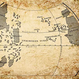
Metal Print : Toscanellis world map, 1474


![]()
Metal Prints from Science Photo Library
Toscanellis world map, 1474
Toscanellis world map. This map was drawn by the Italian mathematician and astronomer Paolo Toscanelli (1397-1482) in 1474. It was used by Christopher Columbus for his first voyage to find a westward route to Asia. The map led him to falsely believe he had found a route to Asia, rather than discovering North America. Engraving by Konrad Kretschmer, Germany, circa 1850
Science Photo Library features Science and Medical images including photos and illustrations
Media ID 6322545
© CCI ARCHIVES/SCIENCE PHOTO LIBRARY
15th Century Cartography Christopher Columbus Drawing Hexagonal Incomplete Incorrect World Map 1474 Mono Chrome
16"x20" (51x41cm) Metal Print
Discover the wonders of historical cartography with our Media Storehouse Metal Prints featuring the iconic Toscanelli World Map from Science Photo Library. Drawn by the esteemed Italian mathematician and astronomer Paolo Toscanelli in 1474, this masterpiece showcases a captivating representation of the known world at the time. Our high-quality metal prints bring the intricate details of this historical map to life, adding a touch of history and sophistication to any space. Experience the allure of the past with this beautiful and educational addition to your home or office décor.
Made with durable metal and luxurious printing techniques, our metal photo prints go beyond traditional canvases, adding a cool, modern touch to your space. Wall mount on back. Eco-friendly 100% post-consumer recycled ChromaLuxe aluminum surface. The thickness of the print is 0.045". Featuring a Scratch-resistant surface and Rounded corners. Backing hangers are attached to the back of the print and float the print 1/2-inch off the wall when hung, the choice of hanger may vary depending on size and International orders will come with Float Mount hangers only. Finished with a brilliant white high gloss surface for unsurpassed detail and vibrance. Printed using Dye-Sublimation and for best care we recommend a non-ammonia glass cleaner, water, or isopropyl (rubbing) alcohol to prevent harming the print surface. We recommend using a clean, lint-free cloth to wipe off the print. The ultra-hard surface is scratch-resistant, waterproof and weatherproof. Avoid direct sunlight exposure.
Made with durable metal and luxurious printing techniques, metal prints bring images to life and add a modern touch to any space
Estimated Image Size (if not cropped) is 50.8cm x 40.6cm (20" x 16")
Estimated Product Size is 51.4cm x 41.2cm (20.2" x 16.2")
These are individually made so all sizes are approximate
Artwork printed orientated as per the preview above, with landscape (horizontal) orientation to match the source image.
FEATURES IN THESE COLLECTIONS
> Asia
> Related Images
> Europe
> Germany
> Related Images
> Europe
> Italy
> Related Images
> Europe
> Related Images
> Maps and Charts
> Early Maps
EDITORS COMMENTS
This print showcases Toscanelli's world map, a significant historical artifact that shaped the course of exploration in the 15th century. Created by Italian mathematician and astronomer Paolo Toscanelli in 1474, this intricate illustration holds immense geographical importance. Used by Christopher Columbus during his inaugural voyage to discover a westward route to Asia, this map ultimately led him astray. The hexagonal design beautifully captures the essence of cartography during that era, with Europe and Asia taking center stage. However, as history would reveal, Columbus mistakenly believed he had reached his intended destination when he stumbled upon North America instead. This incomplete representation of the world inadvertently altered our understanding of geography at the time. Engraved by Konrad Kretschmer in Germany around 1850, this monochrome artwork breathes life into an erroneous depiction that once held great significance. It serves as a reminder of how even renowned explorers like Christopher Columbus could be misled by inaccurate maps. With its rich historical context and artistic allure, this print from Science Photo Library offers viewers a glimpse into an era where cartographic knowledge was still evolving. It stands as a testament to human curiosity and reminds us that even mistakes can lead to remarkable discoveries.
MADE IN THE USA
Safe Shipping with 30 Day Money Back Guarantee
FREE PERSONALISATION*
We are proud to offer a range of customisation features including Personalised Captions, Color Filters and Picture Zoom Tools
SECURE PAYMENTS
We happily accept a wide range of payment options so you can pay for the things you need in the way that is most convenient for you
* Options may vary by product and licensing agreement. Zoomed Pictures can be adjusted in the Cart.