Metal Print > Arts > Artists > W > Frederick de Wit
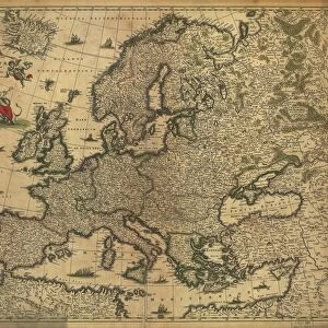
Metal Print : De Wits Atlas of 1689


![]()
Metal Prints from Science Photo Library
De Wits Atlas of 1689
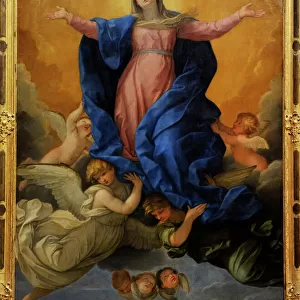
The known World in the late 17th Century. Map of the world taken from the World Atlas of Frederick de Wit, dated 1689. The map is shown as a Fournier projection, the most common of the day, with seperate polar plots. The map shows the extent of contemporary exploration, and some of its errors (California is shown as an island, for example). The map is surrounded by allegorical scenes depicting the rewards of exploration and its pitfalls (reclining man being violently sick near bottom left). There are also references to zodiacal persons and creatures
Science Photo Library features Science and Medical images including photos and illustrations
Media ID 6349187
© GEORGE BERNARD/SCIENCE PHOTO LIBRARY
Ancient Atlas Cartography Circle Circles Earth Science Mapping Maps Round Shape Rounded Circular Sciences World 1689 De Wit
16"x20" (51x41cm) Metal Print
Discover history in a new light with Media Storehouse Metal Prints featuring the De Wit Atlas of 1689 from Science Photo Library. This captivating map, taken from Frederick de Wit's World Atlas, showcases the known world as it appeared in the late 17th century. The intricate details of the Fournier projection, the most common mapping technique of the time, are brought to life in vivid detail on a high-quality metal print. Travel back in time and adorn your walls with this stunning piece of cartographic history.
Made with durable metal and luxurious printing techniques, our metal photo prints go beyond traditional canvases, adding a cool, modern touch to your space. Wall mount on back. Eco-friendly 100% post-consumer recycled ChromaLuxe aluminum surface. The thickness of the print is 0.045". Featuring a Scratch-resistant surface and Rounded corners. Backing hangers are attached to the back of the print and float the print 1/2-inch off the wall when hung, the choice of hanger may vary depending on size and International orders will come with Float Mount hangers only. Finished with a brilliant white high gloss surface for unsurpassed detail and vibrance. Printed using Dye-Sublimation and for best care we recommend a non-ammonia glass cleaner, water, or isopropyl (rubbing) alcohol to prevent harming the print surface. We recommend using a clean, lint-free cloth to wipe off the print. The ultra-hard surface is scratch-resistant, waterproof and weatherproof. Avoid direct sunlight exposure.
Made with durable metal and luxurious printing techniques, metal prints bring images to life and add a modern touch to any space
Estimated Image Size (if not cropped) is 50.8cm x 40.6cm (20" x 16")
Estimated Product Size is 51.4cm x 41.2cm (20.2" x 16.2")
These are individually made so all sizes are approximate
Artwork printed orientated as per the preview above, with landscape (horizontal) orientation to match the source image.
FEATURES IN THESE COLLECTIONS
> Animals
> Mammals
> Cricetidae
> California Mouse
> Arts
> Artists
> W
> Frederick de Wit
> Arts
> Contemporary art
> Arts
> Minimalist artwork
> Geometric shapes
> Contemporary art
> Arts
> Pop art
> Contemporary art
> Contemporary art gallery
> Arts
> Pop art
> Contemporary art
> Fine art gallery
> Maps and Charts
> Early Maps
> Maps and Charts
> Related Images
> Maps and Charts
> World
EDITORS COMMENTS
This print showcases the renowned De Wits Atlas of 1689, offering a glimpse into the known world during the late 17th century. The map, derived from Frederick de Wit's World Atlas, is presented in a Fournier projection - an immensely popular cartographic technique at that time - featuring separate polar plots. As we explore this historical artifact, it becomes evident that while it accurately depicts contemporary exploration efforts, it also reveals some intriguing errors of its era. Notably, California is depicted as an isolated island rather than part of mainland North America. Surrounding the map are allegorical scenes that vividly illustrate both the rewards and pitfalls associated with exploration. Amongst these depictions lies a reclining man who appears to be violently ill near the bottom left corner—a poignant reminder of the perils faced by those venturing into uncharted territories. Furthermore, scattered throughout this remarkable piece are references to zodiacal persons and creatures—symbolic representations that add depth and intrigue to our understanding of early cartography. As we delve into this mesmerizing image capturing centuries-old knowledge and scientific advancements in mapping techniques, we gain insight into how our perception of Earth has evolved over time. This photograph serves as a testament to humanity's insatiable curiosity about our planet's vast mysteries and highlights the significant role played by maps in unraveling them.
MADE IN THE USA
Safe Shipping with 30 Day Money Back Guarantee
FREE PERSONALISATION*
We are proud to offer a range of customisation features including Personalised Captions, Color Filters and Picture Zoom Tools
SECURE PAYMENTS
We happily accept a wide range of payment options so you can pay for the things you need in the way that is most convenient for you
* Options may vary by product and licensing agreement. Zoomed Pictures can be adjusted in the Cart.