Metal Print > Maps and Charts > Germany
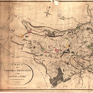
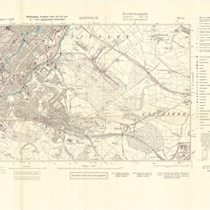
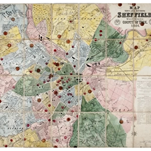
Metal Print : Ordnance Survey map of north Sheffield copied by the Germans, and marked with bombing targets


![]()
Metal Prints from Sheffield City Archives
Ordnance Survey map of north Sheffield copied by the Germans, and marked with bombing targets
Original at Sheffield Local Studiess 26 M/4
Sheffield City Archives and Local Studies Library has an unrivalled collection of images of Sheffield, England
Media ID 14046718
© Sheffield City Council
Attercliffe Brightside Centre City Crookes Cyclops Grimesthorpe Hillsborough Industry Maps Military Owlerton Park Power Reservoirs Stations Steel Valley Walkley Works World Barracks Bombs Godfrey Hadfield Lower Raids Shirecliffe Supply
16"x20" (51x41cm) Metal Print
Discover the fascinating history of Sheffield with our unique Media Storehouse Metal Prints. This captivating design features an authentic Ordnance Survey map of North Sheffield, meticulously copied by the Germans during World War II. Marked with bombing targets from Sheffield City Archives (26 M/4), each detail tells a story of the city's resilience. Bring a piece of local history into your home or office with this intriguing and conversation-starting Metal Print.
Made with durable metal and luxurious printing techniques, our metal photo prints go beyond traditional canvases, adding a cool, modern touch to your space. Wall mount on back. Eco-friendly 100% post-consumer recycled ChromaLuxe aluminum surface. The thickness of the print is 0.045". Featuring a Scratch-resistant surface and Rounded corners. Backing hangers are attached to the back of the print and float the print 1/2-inch off the wall when hung, the choice of hanger may vary depending on size and International orders will come with Float Mount hangers only. Finished with a brilliant white high gloss surface for unsurpassed detail and vibrance. Printed using Dye-Sublimation and for best care we recommend a non-ammonia glass cleaner, water, or isopropyl (rubbing) alcohol to prevent harming the print surface. We recommend using a clean, lint-free cloth to wipe off the print. The ultra-hard surface is scratch-resistant, waterproof and weatherproof. Avoid direct sunlight exposure.
Made with durable metal and luxurious printing techniques, metal prints bring images to life and add a modern touch to any space
Estimated Image Size (if not cropped) is 50.8cm x 40.6cm (20" x 16")
Estimated Product Size is 51.4cm x 41.2cm (20.2" x 16.2")
These are individually made so all sizes are approximate
Artwork printed orientated as per the preview above, with landscape (horizontal) orientation to match the source image.
FEATURES IN THESE COLLECTIONS
> Maps and Charts
> Related Images
> Maps and Charts
> World
> Sheffield City Archives
> Maps and Plans
EDITORS COMMENTS
This print showcases an intriguing piece of history - an Ordnance Survey map of north Sheffield that was copied by the Germans during World War II and marked with bombing targets. The original map can be found at Sheffield Local Studies (26 M/4). The image takes us back to a time when air raids and bombs were a constant threat, reminding us of the immense challenges faced by the people of Sheffield during this tumultuous period. The map highlights significant areas such as Hadfield Dam, reservoirs, Godfrey Old Great Crookes, New Owlerton, City Centre Park, Lower Don Valley, Attercliffe Brightside Steel Industry Atlas Works Cyclops President Grimesthorpe Shirecliffe Power Stations Electricity Supply Hillsborough Barracks Military Walkley. It serves as a poignant reminder of the resilience and strength exhibited by the citizens in safeguarding their city against enemy attacks. This historical artifact not only sheds light on the strategic importance placed on various locations but also offers valuable insights into how communities were affected by war. As we gaze upon this remarkable print from Sheffield City Archives, it is impossible not to appreciate both its historical significance and its ability to transport us back in time. It stands as a testament to the courage displayed by those who lived through these challenging times while providing us with a deeper understanding of Sheffield's rich heritage.
MADE IN THE USA
Safe Shipping with 30 Day Money Back Guarantee
FREE PERSONALISATION*
We are proud to offer a range of customisation features including Personalised Captions, Color Filters and Picture Zoom Tools
SECURE PAYMENTS
We happily accept a wide range of payment options so you can pay for the things you need in the way that is most convenient for you
* Options may vary by product and licensing agreement. Zoomed Pictures can be adjusted in the Cart.