Mouse Mat > Arts > Artists > O > Abraham Ortelius
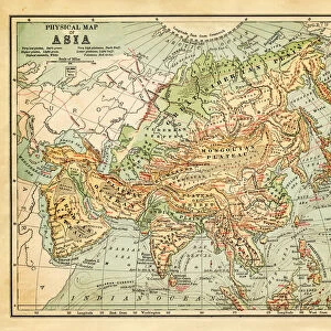
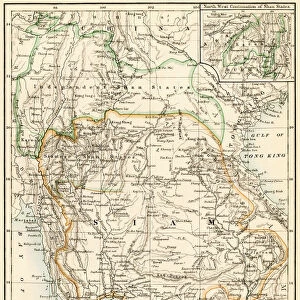
Mouse Mat : Map of East India and South East Asian territory, 1570 (engraving)
")

![]()
Home Decor from Fine Art Finder
Map of East India and South East Asian territory, 1570 (engraving)
LRI4704952 Map of East India and South East Asian territory, 1570 (engraving) by Ortelius, Abraham (1527-98); Museo Navale di Pegli, Genoa, Italy; (add.info.: Indiae Orientalis Insularumque Adiacientium Typus. Geography map of East India and South East Asian territory from " Theatrum Orbis Terrarum" by Abraham Ortelius (Oertel, Ortell or Ortel, 1527-1598), 1570. Genova, Museo Navale); Luisa Ricciarini; Flemish, out of copyright
Media ID 22467646
© Luisa Ricciarini / Bridgeman Images
Atlas Book Borneo Cambodia Cambodian Guinee Indonesia Indonesian Papua New Guinea Sumatra Asian Asian Geographical Map
Mouse Pad
Standard Size Mouse Pad 7.75" x 9..25". High density Neoprene w linen surface. Easy to clean, stain resistant finish. Rounded corners.
Archive quality photographic print in a durable wipe clean mouse mat with non slip backing. Works with all computer mice
Estimated Image Size (if not cropped) is 23.7cm x 17.5cm (9.3" x 6.9")
Estimated Product Size is 23.7cm x 20.2cm (9.3" x 8")
These are individually made so all sizes are approximate
Artwork printed orientated as per the preview above, with landscape (horizontal) orientation to match the source image.
FEATURES IN THESE COLLECTIONS
> Fine Art Finder
> Artists
> Abraham Ortelius
> Animals
> Mammals
> Cricetidae
> Orientalis
> Arts
> Artists
> C
> Cambodian Cambodian
> Arts
> Artists
> O
> Abraham Ortelius
> Asia
> Cambodia
> Related Images
> Asia
> India
> Related Images
> Maps and Charts
> Abraham Ortelius
EDITORS COMMENTS
This engraving, titled "Map of East India and South East Asian territory, 1570" takes us back in time to explore the intricate geography of a bygone era. Created by Abraham Ortelius, a renowned Flemish cartographer, this map offers a glimpse into the vast territories that comprised East India and Southeast Asia during the late 16th century. The detailed craftsmanship of this print invites us to embark on a visual journey through various regions. From the sprawling Indian subcontinent to the enchanting islands of Borneo and Sumatra, every contour is meticulously etched onto paper. The map also encompasses significant parts of China and Japan, showcasing their historical importance within these interconnected trade routes. As we delve deeper into its intricacies, we discover smaller yet equally fascinating details. The presence of Cambodia reminds us of its rich cultural heritage while Papua New Guinea represents Oceania's diverse tapestry. This comprehensive depiction serves as an invaluable resource for historians and geographers alike. Preserved at Museo Navale di Pegli in Genoa, Italy, this particular print holds immense historical significance. Its ageless beauty transcends time as it continues to captivate viewers with its delicate lines and precise notations. Luisa Ricciarini's photograph immortalizes this remarkable piece from Ortelius' "Theatrum Orbis Terrarum". Through her lens, she preserves both artistry and history for generations to come.
MADE IN THE USA
Safe Shipping with 30 Day Money Back Guarantee
FREE PERSONALISATION*
We are proud to offer a range of customisation features including Personalised Captions, Color Filters and Picture Zoom Tools
SECURE PAYMENTS
We happily accept a wide range of payment options so you can pay for the things you need in the way that is most convenient for you
* Options may vary by product and licensing agreement. Zoomed Pictures can be adjusted in the Cart.