Mouse Mat > Arts > Artists > O > Abraham Ortelius
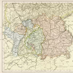
Mouse Mat : Map of the German Netherlands, 1570 (engraving)
")

![]()
Home Decor from Fine Art Finder
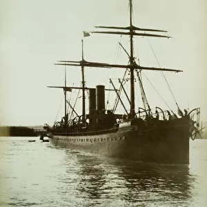
Map of the German Netherlands, 1570 (engraving)
LRI4704434 Map of the German Netherlands, 1570 (engraving) by Ortelius, Abraham (1527-98); Museo Navale di Pegli, Genoa, Italy; (add.info.: Gelriae, Cliviae, Finitimorum Qe Locorum Verissima Descriptio Christiano Schrot. Auctore. Geography map of the territory of the German Netherlands from " Theatrum Orbis Terrarum" by Abraham Ortelius (Oertel, Ortell or Ortel, 1527-1598), 1570. Genova, Museo Navale); Luisa Ricciarini; Flemish, out of copyright
Media ID 23736370
© Luisa Ricciarini / Bridgeman Images
Atlas Book Neerlanders Geographical Map
Mouse Pad
Standard Size Mouse Pad 7.75" x 9..25". High density Neoprene w linen surface. Easy to clean, stain resistant finish. Rounded corners.
Archive quality photographic print in a durable wipe clean mouse mat with non slip backing. Works with all computer mice
Estimated Image Size (if not cropped) is 23.7cm x 18.6cm (9.3" x 7.3")
Estimated Product Size is 23.7cm x 20.2cm (9.3" x 8")
These are individually made so all sizes are approximate
Artwork printed orientated as per the preview above, with landscape (horizontal) orientation to match the source image.
FEATURES IN THESE COLLECTIONS
> Fine Art Finder
> Artists
> Abraham Ortelius
> Arts
> Artists
> O
> Abraham Ortelius
> Europe
> Germany
> Related Images
> Europe
> Italy
> Liguria
> Genoa
> Europe
> Netherlands
> Maps
> Europe
> Netherlands
> Posters
> Europe
> Netherlands
> Related Images
> Maps and Charts
> Abraham Ortelius
EDITORS COMMENTS
This print showcases a remarkable piece of history: the "Map of the German Netherlands, 1570" by Abraham Ortelius. The engraving, now housed in the Museo Navale di Pegli in Genoa, Italy, offers a fascinating glimpse into the geography and territories of this region during the late 16th century. Ortelius, a renowned cartographer from Flanders, meticulously crafted this map as part of his famous work "Theatrum Orbis Terrarum". With intricate details and precision, he presents Gelriae and Cliviae alongside other neighboring locations in what is now known as Belgium and parts of Germany. Christiano Schrot is credited as an author for providing accurate descriptions. Luisa Ricciarini's expert photography captures every nuance of this historical treasure. The image allows us to appreciate not only Ortelius' artistry but also the significance of maps during that era. As we gaze upon it today, we are transported back to a time when exploration and discovery were at their peak. This print serves as a testament to human curiosity and our desire to understand our world better. It reminds us that even centuries later, these ancient maps continue to captivate our imagination and provide valuable insights into our past.
MADE IN THE USA
Safe Shipping with 30 Day Money Back Guarantee
FREE PERSONALISATION*
We are proud to offer a range of customisation features including Personalised Captions, Color Filters and Picture Zoom Tools
SECURE PAYMENTS
We happily accept a wide range of payment options so you can pay for the things you need in the way that is most convenient for you
* Options may vary by product and licensing agreement. Zoomed Pictures can be adjusted in the Cart.