Mouse Mat > Historic > Ancient civilizations > Ancient Greece > Athens
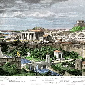
Mouse Mat : Map of the Athenian Empire at its height, c.450 B.C. From Historical Atlas, published 1923 (colour litho)
")

![]()
Home Decor from Fine Art Finder
Map of the Athenian Empire at its height, c.450 B.C. From Historical Atlas, published 1923 (colour litho)
2603503 Map of the Athenian Empire at its height, c.450 B.C. From Historical Atlas, published 1923 (colour litho) by American School, (20th century)
Media ID 38284698
© Bridgeman Images
Athenian Athens Chart Countries Geographical Height
Mouse Pad
Standard Size Mouse Pad 7.75" x 9..25". High density Neoprene w linen surface. Easy to clean, stain resistant finish. Rounded corners.
Archive quality photographic print in a durable wipe clean mouse mat with non slip backing. Works with all computer mice
Estimated Image Size (if not cropped) is 23.7cm x 18.5cm (9.3" x 7.3")
Estimated Product Size is 23.7cm x 20.2cm (9.3" x 8")
These are individually made so all sizes are approximate
Artwork printed orientated as per the preview above, with landscape (horizontal) orientation to match the source image.
FEATURES IN THESE COLLECTIONS
> Fine Art Finder
> Artists
> American School
> Europe
> Greece
> Related Images
> Historic
> Ancient civilizations
> Ancient Greece
> Athens
> Historic
> Ancient civilizations
> Ancient Greece
> Greek history
> Maps and Charts
> Early Maps
> Maps and Charts
> Related Images
EDITORS COMMENTS
This stunning print captures the Map of the Athenian Empire at its height, circa 450 B.C. The intricate details and vibrant colors bring to life the ancient world of Athens, Greece during this pivotal time in history.
Published in 1923 as part of a Historical Atlas, this color lithograph showcases the vast extent of the Athenian Empire, stretching across Europe and beyond. The map is a testament to the power and influence that Athens held over other countries during this era.
As you study this map, you can't help but marvel at the geographical scope of the empire and imagine what life was like for those living within its borders. From bustling cities to remote villages, each location on the map tells a story of ancient civilizations and cultures.
The historical significance of this map cannot be overstated. It provides valuable insight into how empires were formed and maintained thousands of years ago. It serves as a reminder of our shared human history and how societies have evolved over time.
Whether you are a history buff or simply appreciate fine art, this print is sure to captivate your imagination and transport you back in time to when Athens reigned supreme as a dominant force in the ancient world.
MADE IN THE USA
Safe Shipping with 30 Day Money Back Guarantee
FREE PERSONALISATION*
We are proud to offer a range of customisation features including Personalised Captions, Color Filters and Picture Zoom Tools
SECURE PAYMENTS
We happily accept a wide range of payment options so you can pay for the things you need in the way that is most convenient for you
* Options may vary by product and licensing agreement. Zoomed Pictures can be adjusted in the Cart.