Mouse Mat > Arts > Artists > M > Gerardus Mercator
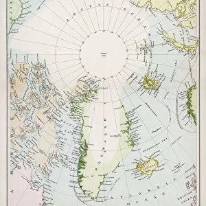
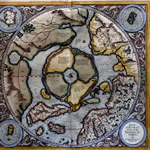
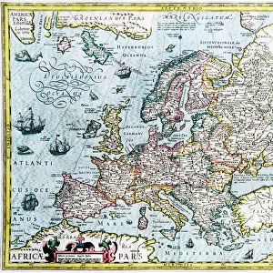
Mouse Mat : Septentrionalium terrarum descriptio, map of the Arctic, 1595 (engraving)
")

![]()
Home Decor from Fine Art Finder
Septentrionalium terrarum descriptio, map of the Arctic, 1595 (engraving)
STC126924 Septentrionalium terrarum descriptio, map of the Arctic, 1595 (engraving) by Mercator, Gerardus (1512-94); Private Collection; (add.info.: first separate map of the Arctic region; ); The Stapleton Collection; Flemish, out of copyright
Media ID 23367536
© The Stapleton Collection / Bridgeman Images
Greenland Iceland North Pole Faroe Islands
Mouse Pad
Standard Size Mouse Pad 7.75" x 9..25". High density Neoprene w linen surface. Easy to clean, stain resistant finish. Rounded corners.
Archive quality photographic print in a durable wipe clean mouse mat with non slip backing. Works with all computer mice
Estimated Product Size is 23.7cm x 20.2cm (9.3" x 8")
These are individually made so all sizes are approximate
Artwork printed orientated as per the preview above, with landscape (horizontal) orientation to match the source image.
FEATURES IN THESE COLLECTIONS
> Fine Art Finder
> Artists
> American School
> Fine Art Finder
> Artists
> Gerardus Mercator
> Fine Art Finder
> Maps (celestial & Terrestrial)
> Arts
> Artists
> M
> Gerardus Mercator
> Europe
> Iceland
> Related Images
> Europe
> Russia
> Related Images
> Maps and Charts
> Gerardus Mercator's Cartographic
> Maps and Charts
> Related Images
EDITORS COMMENTS
This print showcases the "Septentrionalium terrarum descriptio" a remarkable map of the Arctic created by Gerardus Mercator in 1595. The engraving, now part of a private collection, is considered to be the first separate map solely dedicated to depicting the Arctic region. Mercator's meticulous attention to detail is evident in this masterpiece as he expertly captures various geographical features and landmarks. From the North Pole to Asia, Russia, Faroe Islands, America, Iceland, and Greenland, every element on this map has been intricately engraved. The historical significance of this artwork cannot be overstated. It offers us a glimpse into how early cartographers perceived and understood these remote regions during an era when exploration was limited. This map serves as a testament to Mercator's pioneering spirit and his contribution towards expanding our knowledge of uncharted territories. As we gaze upon this enchanting engraving from Bridgeman Images' Stapleton Collection, we are transported back in time – imagining intrepid explorers navigating treacherous waters or indigenous communities thriving amidst icy landscapes. It reminds us of humanity's enduring curiosity about distant lands and our relentless pursuit of discovery. This print not only celebrates Mercator's artistic brilliance but also invites us to appreciate the rich history behind cartography and its role in shaping our understanding of the world.
MADE IN THE USA
Safe Shipping with 30 Day Money Back Guarantee
FREE PERSONALISATION*
We are proud to offer a range of customisation features including Personalised Captions, Color Filters and Picture Zoom Tools
SECURE PAYMENTS
We happily accept a wide range of payment options so you can pay for the things you need in the way that is most convenient for you
* Options may vary by product and licensing agreement. Zoomed Pictures can be adjusted in the Cart.