Mouse Mat > Arts > Artists > O > Oceanic Oceanic
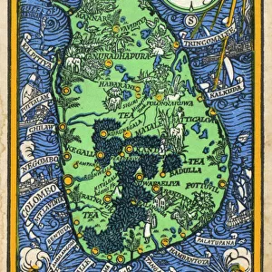
Mouse Mat : Map of Southern India and Ceylon, after a work made circa 1720 by Dutch cartographer


![]()
Home Decor from Fine Art Finder
Map of Southern India and Ceylon, after a work made circa 1720 by Dutch cartographer
5892377 Map of Southern India and Ceylon, after a work made circa 1720 by Dutch cartographer Adriaan Reland (engraving) by Reland, Adriaan (1676-1718) (after); Private Collection; Dutch, out of copyright
Media ID 22587808
© Bridgeman Images
Archival Archive Ceylon Chart Countries Geographical Indian Ocean Islands Sri Lanka Tamil Nadu
Mouse Pad
Standard Size Mouse Pad 7.75" x 9..25". High density Neoprene w linen surface. Easy to clean, stain resistant finish. Rounded corners.
Archive quality photographic print in a durable wipe clean mouse mat with non slip backing. Works with all computer mice
Estimated Product Size is 23.7cm x 20.2cm (9.3" x 8")
These are individually made so all sizes are approximate
Artwork printed orientated as per the preview above, with landscape (horizontal) or portrait (vertical) orientation to match the source image.
FEATURES IN THESE COLLECTIONS
> Fine Art Finder
> Artists
> Antonio (after) Canaletto
> Arts
> Artists
> O
> Oceanic Oceanic
> Asia
> India
> Related Images
> Asia
> Sri Lanka
> Related Images
> Maps and Charts
> Early Maps
> Maps and Charts
> India
> Maps and Charts
> Related Images
EDITORS COMMENTS
This print showcases a remarkable piece of history - the "Map of Southern India and Ceylon" created by Dutch cartographer Adriaan Reland around 1720. The intricate details captured in this engraving transport us back to a time when exploration and discovery were at their peak. The map depicts the southern region of India, including the enchanting island of Ceylon (now known as Sri Lanka). It offers an invaluable glimpse into the geographical landscape, with its Indian Ocean backdrop and scattered islands dotting the vast expanse. Notably, it highlights Adam's Bridge, also known as Rama Setu or Ramas Bridge, connecting Tamil Nadu to Mannar Island across the Gulf of Mannar. As we delve into this historical archive, we are reminded of how maps have played an essential role in shaping our understanding of different countries and cultures throughout time. This particular map serves as a testament to Reland's expertise in charting unexplored territories during his era. With its aged appearance and delicate engravings, this 18th-century masterpiece transports us back to an era where cartography was both artistry and science. It invites us to appreciate not only the beauty but also the significance that lies within these ancient maps. Thanks to Fine Art Finder for preserving this valuable piece from a private collection. Through Ken Welsh's lens, we can now admire this stunning work while contemplating its rich historical context.
MADE IN THE USA
Safe Shipping with 30 Day Money Back Guarantee
FREE PERSONALISATION*
We are proud to offer a range of customisation features including Personalised Captions, Color Filters and Picture Zoom Tools
SECURE PAYMENTS
We happily accept a wide range of payment options so you can pay for the things you need in the way that is most convenient for you
* Options may vary by product and licensing agreement. Zoomed Pictures can be adjusted in the Cart.