Mouse Mat > Europe > France > Paris > Maps
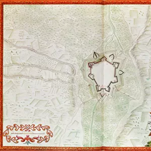
Mouse Mat : Map showing the military campaigns of Louis XIV in the Low Countries


![]()
Home Decor from Fine Art Finder
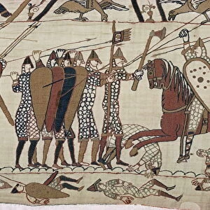
Map showing the military campaigns of Louis XIV in the Low Countries
741366 Map showing the military campaigns of Louis XIV in the Low Countries, from Atlas geographique et militaire, published in Paris, 1763 (colour engraving) by Rizzi-Zannoni, Giovanni Antonio (1736-1814); Archives du Ministere des Affaires Etrangeres, Paris, France; (add.info.: Campagnes de Louis XIV dans les Pays Bas; Louis XIV (1638-1715) King of France (1643-1715); map shows the places and dates of the chief battles and engagements during the period from 1643 until 1711; ); Italian, out of copyright
Media ID 23485706
© Bridgeman Images
Aggression Atlas Battles Bourbons Dynasty Campaigns House Of Bourbons France Louis The Great Louis Xiv Louis Xiv King Of France 1638 1715 Low Countries Pays Bas The Sun King
Mouse Pad
Standard Size Mouse Pad 7.75" x 9..25". High density Neoprene w linen surface. Easy to clean, stain resistant finish. Rounded corners.
Archive quality photographic print in a durable wipe clean mouse mat with non slip backing. Works with all computer mice
Estimated Product Size is 23.7cm x 20.2cm (9.3" x 8")
These are individually made so all sizes are approximate
Artwork printed orientated as per the preview above, with landscape (horizontal) or portrait (vertical) orientation to match the source image.
FEATURES IN THESE COLLECTIONS
> Fine Art Finder
> Artists
> Austrian School
> Fine Art Finder
> Maps (celestial & Terrestrial)
> Europe
> France
> Paris
> Maps
> Europe
> Netherlands
> Maps
> Europe
> Netherlands
> Posters
> Europe
> Netherlands
> Related Images
> Historic
> Battles
> Related Images
EDITORS COMMENTS
This print showcases a historical map depicting the military campaigns of Louis XIV in the Low Countries. Published in Paris in 1763, this color engraving is part of the renowned Atlas geographique et militaire by Giovanni Antonio Rizzi-Zannoni. The image, sourced from the Archives du Ministere des Affaires Etrangeres in Paris, France, offers a fascinating glimpse into the aggressive campaign strategies employed by Louis XIV during his reign as King of France. The map meticulously outlines the places and dates of significant battles and engagements that took place between 1643 and 1711. As one delves into this visual representation of history, it becomes evident how Louis XIV's military prowess shaped the destiny of not only France but also the Low Countries. Known as "the Sun King". Louis XIV was a prominent figure who reigned over France with grandeur and power. This print serves as an invaluable resource for historians and enthusiasts alike who seek to understand and appreciate the complexities of warfare during this era. It sheds light on both political ambitions and territorial conquests that characterized Louis XIV's rule. With its intricate details and vibrant colors, this engraving transports viewers back to a time when military campaigns were fought with valor on European soil.
MADE IN THE USA
Safe Shipping with 30 Day Money Back Guarantee
FREE PERSONALISATION*
We are proud to offer a range of customisation features including Personalised Captions, Color Filters and Picture Zoom Tools
SECURE PAYMENTS
We happily accept a wide range of payment options so you can pay for the things you need in the way that is most convenient for you
* Options may vary by product and licensing agreement. Zoomed Pictures can be adjusted in the Cart.