Mouse Mat > Fine Art Finder > Maps (celestial & Terrestrial)
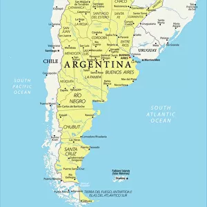
Mouse Mat : Chile, from the south of Peru to Cape Horn, from Atlas de Toutes les Parties

![]()
Home Decor from Fine Art Finder
Chile, from the south of Peru to Cape Horn, from Atlas de Toutes les Parties
KW205856 Chile, from the south of Peru to Cape Horn, from Atlas de Toutes les Parties Connues du Globe Terrestre by Guillaume Raynal (1713-96) published Geneva, 1780 (coloured engraving) by Bonne, Charles Marie Rigobert (1727-95); Private Collection; Ken Welsh; French, out of copyright
Media ID 12755455
© www.bridgemanimages.com
Argentina Bolivia Falkland Islands Paraguay Tierra Del Fuego Uruguay
Mouse Pad
Standard Size Mouse Pad 7.75" x 9..25". High density Neoprene w linen surface. Easy to clean, stain resistant finish. Rounded corners.
Archive quality photographic print in a durable wipe clean mouse mat with non slip backing. Works with all computer mice
Estimated Image Size (if not cropped) is 16.3cm x 23.7cm (6.4" x 9.3")
Estimated Product Size is 20.2cm x 23.7cm (8" x 9.3")
These are individually made so all sizes are approximate
Artwork printed orientated as per the preview above, with portrait (vertical) orientation to match the source image.
FEATURES IN THESE COLLECTIONS
> Fine Art Finder
> Artists
> Charles Marie Rigobert Bonne
> Fine Art Finder
> Maps (celestial & Terrestrial)
EDITORS COMMENTS
This print showcases the remarkable beauty and vastness of Chile, stretching all the way from the southern region of Peru to Cape Horn. Taken from the renowned Atlas de Toutes les Parties Connues du Globe Terrestre by Guillaume Raynal, this colored engraving offers a glimpse into the rich history and geographical diversity of South America. The image captures an intricate map that highlights not only Chile but also neighboring countries such as Argentina, Paraguay, Uruguay, Bolivia, Tierra del Fuego, and even the Falkland Islands. The level of detail is truly impressive, allowing viewers to explore various regions and their unique features. From towering mountain ranges to sprawling coastlines along the Pacific Ocean, Chile's natural wonders are beautifully depicted in this print. It serves as a visual testament to its diverse landscapes – from arid deserts in the north to lush forests in central regions and icy fjords in Patagonia. As we admire this historical piece of cartography created by Charles Marie Rigobert Bonne in 1780 Geneva, it reminds us of how far our understanding of geography has come over centuries. This artwork transports us back in time while simultaneously celebrating both human curiosity and artistic skill. With its vibrant colors and intricate details meticulously preserved through time, this print invites us on a journey through one of South America's most awe-inspiring countries - Chile.
MADE IN THE USA
Safe Shipping with 30 Day Money Back Guarantee
FREE PERSONALISATION*
We are proud to offer a range of customisation features including Personalised Captions, Color Filters and Picture Zoom Tools
SECURE PAYMENTS
We happily accept a wide range of payment options so you can pay for the things you need in the way that is most convenient for you
* Options may vary by product and licensing agreement. Zoomed Pictures can be adjusted in the Cart.