Mouse Mat > Africa > Cape Verde > Maps
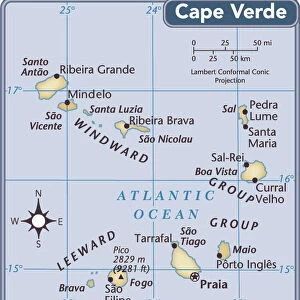
Mouse Mat : Map: Cape Verd Islands, from the Admiralty Survey (colour litho)
")

![]()
Home Decor from Fine Art Finder
Map: Cape Verd Islands, from the Admiralty Survey (colour litho)
6004712 Map: Cape Verd Islands, from the Admiralty Survey (colour litho) by English School, (19th century); Private Collection; (add.info.: Cape Verd Islands, from the Admiralty Survey. Illustration for A Gazetteer of the World or Dictionary of Geographical Knowledge (A Fullarton, 1858).); © Look and Learn; English, out of copyright
Media ID 22771290
© Look and Learn / Bridgeman Images
1850s Victoria Cape Verde Islands
Mouse Pad
Standard Size Mouse Pad 7.75" x 9..25". High density Neoprene w linen surface. Easy to clean, stain resistant finish. Rounded corners.
Archive quality photographic print in a durable wipe clean mouse mat with non slip backing. Works with all computer mice
Estimated Image Size (if not cropped) is 23.7cm x 14.9cm (9.3" x 5.9")
Estimated Product Size is 23.7cm x 20.2cm (9.3" x 8")
These are individually made so all sizes are approximate
Artwork printed orientated as per the preview above, with landscape (horizontal) orientation to match the source image.
FEATURES IN THESE COLLECTIONS
> Fine Art Finder
> Artists
> English School
> Africa
> Cape Verde
> Maps
> Africa
> Cape Verde
> Related Images
> Maps and Charts
> Early Maps
> Maps and Charts
> Related Images
> Maps and Charts
> World
EDITORS COMMENTS
This print showcases a beautifully detailed map of the Cape Verde Islands, created by the English School in the 19th century. The vibrant colors and intricate lithography bring this historical piece to life, offering a glimpse into the world of cartography during that era. Originally featured in A Gazetteer of the World or Dictionary of Geographical Knowledge published by Fullarton in 1858, this map was part of an Admiralty Survey. It provides valuable insights into the geographical knowledge available at that time. The Cape Verde Islands, located off the coast of West Africa, are depicted with utmost precision and accuracy. Each island is meticulously labeled, allowing viewers to explore their names and unique characteristics. This print serves as both an educational tool for geography enthusiasts and a visual delight for art lovers. Preserved within a private collection, this remarkable piece offers us a window into history. As we admire its beauty today, we can appreciate how maps like these were essential tools for explorers and navigators during Victoria's reign. Thanks to Bridgeman Images' preservation efforts, this extraordinary artwork has been made accessible to all who appreciate fine art and historical artifacts alike. Let it transport you back to the mid-19th century when cartographers diligently mapped our world with passion and precision.
MADE IN THE USA
Safe Shipping with 30 Day Money Back Guarantee
FREE PERSONALISATION*
We are proud to offer a range of customisation features including Personalised Captions, Color Filters and Picture Zoom Tools
SECURE PAYMENTS
We happily accept a wide range of payment options so you can pay for the things you need in the way that is most convenient for you
* Options may vary by product and licensing agreement. Zoomed Pictures can be adjusted in the Cart.