Mouse Mat > Europe > Luxembourg > Maps
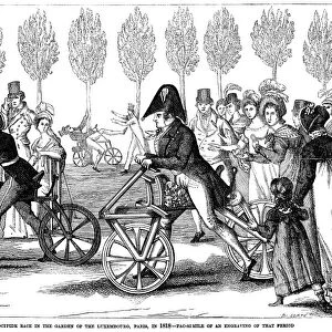
Mouse Mat : Map of Luxemburg and the Frontiers of France and Germany (engraving)
")

![]()
Home Decor from Fine Art Finder
Map of Luxemburg and the Frontiers of France and Germany (engraving)
1611062 Map of Luxemburg and the Frontiers of France and Germany (engraving) by English School, (19th century); Private Collection; (add.info.: Map of Luxemburg and the Frontiers of France and Germany. Illustration for The Illustrated London News, 20 April 1867.
English School (19th Century)); Look and Learn / Illustrated Papers Collection
Media ID 23097260
© Look and Learn / Illustrated Papers Collection / Bridgeman Images
Frontiers Grand Duchy Of Luxembourg Luxembourg Luxembourgers Luxemburg Benelux Countries
Mouse Pad
Standard Size Mouse Pad 7.75" x 9..25". High density Neoprene w linen surface. Easy to clean, stain resistant finish. Rounded corners.
Archive quality photographic print in a durable wipe clean mouse mat with non slip backing. Works with all computer mice
Estimated Image Size (if not cropped) is 23.7cm x 18.5cm (9.3" x 7.3")
Estimated Product Size is 23.7cm x 20.2cm (9.3" x 8")
These are individually made so all sizes are approximate
Artwork printed orientated as per the preview above, with landscape (horizontal) orientation to match the source image.
FEATURES IN THESE COLLECTIONS
> Fine Art Finder
> Artists
> English School
> Europe
> Luxembourg
> Maps
> Europe
> Luxembourg
> Posters
> Europe
> Luxembourg
> Related Images
> Maps and Charts
> Luxembourg
> Maps and Charts
> Related Images
EDITORS COMMENTS
This engraving from the 19th century showcases a detailed "Map of Luxemburg and the Frontiers of France and Germany". The print, created by an English School artist, offers a glimpse into the intricate borders between these European nations. The map provides valuable insights into the historical context of Luxemburg, France, and Germany during that era. It was originally featured in The Illustrated London News on April 20th, 1867. This particular artwork is part of a private collection and has been preserved to showcase its significance. As we explore this engraving, we are transported back in time to witness the complex frontiers that once divided these countries. From North Germany to French overseas departments and territories, every detail has been meticulously captured. Not only does this map depict geographical boundaries but it also hints at cultural influences within each region. Germanic traditions merge with French culture as Luxembourgers navigate their unique identity within the Grand Duchy of Luxembourg. Intriguingly, this historic piece reminds us of Europe's ever-evolving landscape and its role in shaping both national identities and international relationships. As we gaze upon this fine art print from Bridgeman Images' collection, we can appreciate how maps serve as windows into our past while offering new perspectives on our present reality.
MADE IN THE USA
Safe Shipping with 30 Day Money Back Guarantee
FREE PERSONALISATION*
We are proud to offer a range of customisation features including Personalised Captions, Color Filters and Picture Zoom Tools
SECURE PAYMENTS
We happily accept a wide range of payment options so you can pay for the things you need in the way that is most convenient for you
* Options may vary by product and licensing agreement. Zoomed Pictures can be adjusted in the Cart.