Mouse Mat > Arts > Artists > D > Hendrick Doncker
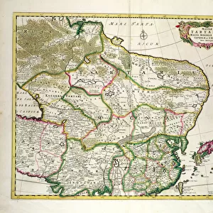
Mouse Mat : Pas-caert van Texel tot aen de Hoofden, 1661 (print, paper)
")

![]()
Home Decor from Fine Art Finder
Pas-caert van Texel tot aen de Hoofden, 1661 (print, paper)
7340060 Pas-caert van Texel tot aen de Hoofden, 1661 (print, paper) by Doncker, Hendrick (c.1626-99); 46.5x57.5 cm; National Maritime Museum, London, UK; (add.info.: Creator: Hendrik Doncker
Bound sheet. Hand col engr. Cartographic Note: Borders graduated for latitude. Scales in Dutch, Spanish and English and French miles [actually leagues]. Additional Places: North Sea, Thames estuary, Netherlands. Bound in De Zee-Atlas ofte Water-wareld, published by Doncker in 1661.); © National Maritime Museum, Greenwich, London
Media ID 38372196
© © National Maritime Museum, Greenwich, London / Bridgeman Images
British Channel English Channel North Sea Riverthames Dutch Netherlands Hollander Hollanders Netherland Netherlands Holland Dutch The Netherland
Mouse Pad
Standard Size Mouse Pad 7.75" x 9..25". High density Neoprene w linen surface. Easy to clean, stain resistant finish. Rounded corners.
Archive quality photographic print in a durable wipe clean mouse mat with non slip backing. Works with all computer mice
Estimated Image Size (if not cropped) is 23.7cm x 18.8cm (9.3" x 7.4")
Estimated Product Size is 23.7cm x 20.2cm (9.3" x 8")
These are individually made so all sizes are approximate
Artwork printed orientated as per the preview above, with landscape (horizontal) orientation to match the source image.
FEATURES IN THESE COLLECTIONS
> Fine Art Finder
> Artists
> Frederick de Wit
> Fine Art Finder
> Artists
> Hendrick Doncker
> Arts
> Artists
> D
> Hendrick Doncker
> Europe
> Netherlands
> Maps
> Europe
> Netherlands
> Posters
> Europe
> Netherlands
> Related Images
> Europe
> Netherlands
> Rivers
> Europe
> Republic of Ireland
> Maps
> Europe
> Spain
> Related Images
EDITORS COMMENTS
This stunning print of Pas-caert van Texel tot aen de Hoofden, created by Hendrick Doncker in 1661, showcases the intricate artistry and precision of 17th-century cartography. The map spans from Texel to the Hoofden, with borders graduated for latitude and scales in Dutch, Spanish, English, and French miles. It is bound in 'De Zee-Atlas ofte Water-wareld', a publication by Doncker that exemplifies his expertise in maritime navigation.
The vibrant hand-colored engravings bring this historical map to life, capturing the essence of European exploration and trade during this period. The detailed depiction of rivers, seas, and coastlines provides a glimpse into the interconnectedness of nations through waterways.
As you study this piece closely, you can imagine sailors using similar maps to navigate treacherous waters and discover new lands. The North Sea, Thames estuary, Netherlands are all prominently featured on this map - key locations for maritime travel during the 17th century.
This print is not just a visual representation but also a historical artifact that tells the story of early European cartography. It serves as a reminder of our enduring fascination with maps as tools for understanding our world and its vast possibilities.
MADE IN THE USA
Safe Shipping with 30 Day Money Back Guarantee
FREE PERSONALISATION*
We are proud to offer a range of customisation features including Personalised Captions, Color Filters and Picture Zoom Tools
SECURE PAYMENTS
We happily accept a wide range of payment options so you can pay for the things you need in the way that is most convenient for you
* Options may vary by product and licensing agreement. Zoomed Pictures can be adjusted in the Cart.