Mouse Mat > Asia > China > Maps
Mouse Mat : Asia - 1680


![]()
Home Decor from Fine Art Finder
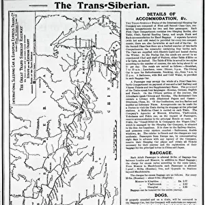
Asia - 1680
2902849 Asia - 1680; (add.info.: Asia in praecipuas ipsius partes distributa, ad ovesrvationes academiae regiae scientiarum, et exquisitissimas tabulas, quae nunquam antehac lucem viderunt, excuasa - Petro vander Aa, cum privilegio ordinum holiandiae et westerisiae; Insets maps: Kamchadka to Korea to Indo-China; Beijing, China to Yellow Sea. Insets maps: Kamchadka to Korea to Indo-China; Beijing, China to Yellow Sea.); Buyenlarge Archive/UIG
Media ID 38414596
© Buyenlarge Archive/UIG / Bridgeman Images
Cartographic Chineze Kamchatka Korea Korean Koreans Yellow Sea Asiae Chineses
Mouse Pad
Standard Size Mouse Pad 7.75" x 9..25". High density Neoprene w linen surface. Easy to clean, stain resistant finish. Rounded corners.
Archive quality photographic print in a durable wipe clean mouse mat with non slip backing. Works with all computer mice
Estimated Image Size (if not cropped) is 23.7cm x 17.5cm (9.3" x 6.9")
Estimated Product Size is 23.7cm x 20.2cm (9.3" x 8")
These are individually made so all sizes are approximate
Artwork printed orientated as per the preview above, with landscape (horizontal) orientation to match the source image.
FEATURES IN THESE COLLECTIONS
> Fine Art Finder
> Artists
> Raymond de la Neziere
> Maps and Charts
> Related Images
EDITORS COMMENTS
This stunning print of Asia from 1680 captures the intricate and detailed cartography of the continent during that time period. Created by Dutch cartographer Petro vander Aa, this map is a true work of art, showcasing Asia divided into its various regions with precision and accuracy.
The map includes insets highlighting areas such as Kamchadka to Korea and Indo-China, as well as Beijing to the Yellow Sea. These insets provide a closer look at these specific regions, allowing viewers to appreciate the level of detail put into this piece.
As one explores this historical map, they can see the influence of European exploration and trade in Asia during the 17th century. The intricate borders and labels give insight into how Europeans perceived and interacted with Asian countries at that time.
This print is not just a map but a window into the past, offering a glimpse into how people viewed and understood geography centuries ago. It serves as a reminder of the rich history and cultural exchange between Europe and Asia during this period.
Overall, this print is not only visually captivating but also holds immense historical significance for those interested in cartography, Asian history, or cultural studies.
MADE IN THE USA
Safe Shipping with 30 Day Money Back Guarantee
FREE PERSONALISATION*
We are proud to offer a range of customisation features including Personalised Captions, Color Filters and Picture Zoom Tools
SECURE PAYMENTS
We happily accept a wide range of payment options so you can pay for the things you need in the way that is most convenient for you
* Options may vary by product and licensing agreement. Zoomed Pictures can be adjusted in the Cart.