Mouse Mat > Asia > Malaysia > Maps
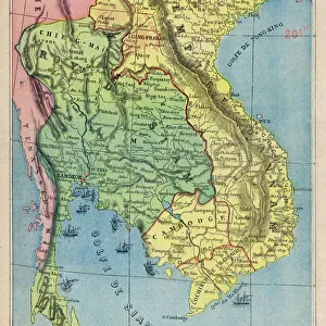
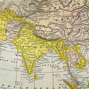
Mouse Mat : Map of Malacca peninsula (Burma, Thailand and Malaysia), circa 1870. 19th century lithography
, circa 1870. 19th century lithography")
![]()
Home Decor from Fine Art Finder
Map of Malacca peninsula (Burma, Thailand and Malaysia), circa 1870. 19th century lithography
NWI4865582 Map of Malacca peninsula (Burma, Thailand and Malaysia), circa 1870. 19th century lithography.; (add.info.: Map of Malacca peninsula (Burma, Thailand and Malaysia), circa 1870. 19th century lithography.); Photo © North Wind Pictures
Media ID 38335536
© © North Wind Pictures / Bridgeman Images
Burma Burmese Malaysia Malaysian South East Asia Thai Thailand Thailands Asiae Asian Asian Geographical Map
Mouse Pad
Standard Size Mouse Pad 7.75" x 9..25". High density Neoprene w linen surface. Easy to clean, stain resistant finish. Rounded corners.
Archive quality photographic print in a durable wipe clean mouse mat with non slip backing. Works with all computer mice
Estimated Image Size (if not cropped) is 17.8cm x 23.7cm (7" x 9.3")
Estimated Product Size is 20.2cm x 23.7cm (8" x 9.3")
These are individually made so all sizes are approximate
Artwork printed orientated as per the preview above, with portrait (vertical) orientation to match the source image.
FEATURES IN THESE COLLECTIONS
> Fine Art Finder
> Artists
> Spanish School (after)
> Asia
> Malaysia
> Related Images
> Asia
> Myanmar
> Related Images
> Asia
> Thailand
> Related Images
> Asia
> Turkmenistan
> Maps
> Maps and Charts
> Early Maps
> Maps and Charts
> Related Images
EDITORS COMMENTS
This stunning lithograph print from the 19th century showcases a detailed map of the Malacca peninsula, encompassing Burma, Thailand, and Malaysia. The intricate lines and labels on the map provide a glimpse into the geographical landscape of this region during that time period.
The vibrant colors used in this lithograph bring to life the diverse cultures and landscapes of Asia in the 1800s. From the lush greenery of Thailand to the historical sites of Burma, each area is depicted with precision and care by the engraver.
As we study this map, we can imagine travelers using it as a guide to navigate through bustling cities and serene countryside. It serves as a reminder of how important maps were for exploration and trade in centuries past.
This Map of Malacca peninsula is not just a piece of art but also a valuable historical document that sheds light on the interconnectedness of nations in Southeast Asia. It captures an era when borders were fluid, cultures intertwined, and trade routes flourished.
Thanks to North Wind Pictures for preserving this exquisite piece from our past. Let us continue to appreciate such treasures that offer us insight into our shared history and heritage.
MADE IN THE USA
Safe Shipping with 30 Day Money Back Guarantee
FREE PERSONALISATION*
We are proud to offer a range of customisation features including Personalised Captions, Color Filters and Picture Zoom Tools
SECURE PAYMENTS
We happily accept a wide range of payment options so you can pay for the things you need in the way that is most convenient for you
* Options may vary by product and licensing agreement. Zoomed Pictures can be adjusted in the Cart.