Mouse Mat > Maps and Charts > Related Images
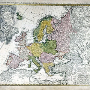
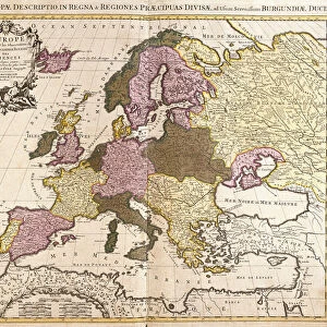
Mouse Mat : Map of Europe, 16th century


![]()
Home Decor from Fine Art Finder
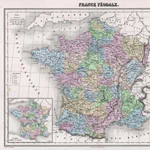
Map of Europe, 16th century
XEE4108664 Map of Europe, 16th century. by Unknown Artist, (16th century); Private Collection; (add.info.: Map of Europe, 16th century.); Stefano Bianchetti; out of copyright
Media ID 22474906
© Stefano Bianchetti / Bridgeman Images
Bianchettinum Geographical Map
Mouse Pad
Standard Size Mouse Pad 7.75" x 9..25". High density Neoprene w linen surface. Easy to clean, stain resistant finish. Rounded corners.
Archive quality photographic print in a durable wipe clean mouse mat with non slip backing. Works with all computer mice
Estimated Image Size (if not cropped) is 23.7cm x 18.3cm (9.3" x 7.2")
Estimated Product Size is 23.7cm x 20.2cm (9.3" x 8")
These are individually made so all sizes are approximate
Artwork printed orientated as per the preview above, with landscape (horizontal) orientation to match the source image.
FEATURES IN THESE COLLECTIONS
> Fine Art Finder
> Artists
> Unknown Artist
> Maps and Charts
> Related Images
EDITORS COMMENTS
This print showcases a remarkable piece of history - a Map of Europe from the 16th century. Crafted by an unknown artist, this intricate map offers us a glimpse into the geographical and political landscape of Europe during that era. With its delicate details and exquisite craftsmanship, the map takes us on a journey through time, allowing us to explore the boundaries and territories that shaped Europe in the 1500s. From majestic mountain ranges to winding rivers, every feature is meticulously depicted, revealing both familiar landmarks and long-forgotten regions. As we gaze upon this ancient cartographic masterpiece, we are reminded of how much has changed over centuries. The borders have shifted, empires have risen and fallen, yet this map remains as a testament to our collective past. The photographer Stefano Bianchetti has skillfully captured every nuance of this historical artifact with his lens. Through his expert composition and lighting techniques, he brings out the richness of colors and textures present in the original artwork. This print invites us to immerse ourselves in European history - to ponder upon the journeys taken by explorers or envision battles fought for power and dominance. It serves as a reminder that maps not only guide our physical travels but also offer glimpses into cultural heritage and human aspirations throughout time. A true treasure for any history enthusiast or lover of fine art alike, this Map of Europe from the 16th century transports us back in time while igniting our curiosity about what lies beyond its edges.
MADE IN THE USA
Safe Shipping with 30 Day Money Back Guarantee
FREE PERSONALISATION*
We are proud to offer a range of customisation features including Personalised Captions, Color Filters and Picture Zoom Tools
SECURE PAYMENTS
We happily accept a wide range of payment options so you can pay for the things you need in the way that is most convenient for you
* Options may vary by product and licensing agreement. Zoomed Pictures can be adjusted in the Cart.