Mouse Mat > Africa > Cape Verde > Maps
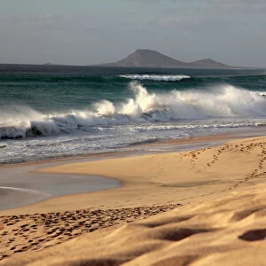
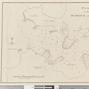
Mouse Mat : Page 3a Chart of Port Praya in the Island of St Jago, Cape Verde Islands


![]()
Home Decor from Fine Art Finder
Page 3a Chart of Port Praya in the Island of St Jago, Cape Verde Islands
5670253 Page 3a Chart of Port Praya in the Island of St Jago, Cape Verde Islands. Titled Port Praya in the Island St Jago one of the Cape de Verds sic A scale of 2 to 1/2 a mile / A View of Port Praya taken from the anchoring place.", 1768-75 (w/c, pen & ink) by Hodges, William (1744-97); Mitchell Library, State Library of New South Wales; (add.info.: Original Sketches, Drawings, Maps etc Collected by Admiral Isaac Smith / drawings and watercolours, mainly of Captain Cooks Second Voyage (1772-1775) by William Hodges, Henry Roberts etc
Dimensions: Album measures 49 x 70 cm); Mitchell Library, State Library of New South Wales; English, out of copyright
Media ID 23272586
© Mitchell Library, State Library of New South Wales / Bridgeman Images
Bleak Cartographic Chart Cooks Second Voyage Elevation Geographical Grey Hydrographic Islands Isolated Land Mapping Numbered Numbers Second Voyage Of Captain Cook Survey Surveying Cabo Verde
Mouse Pad
Standard Size Mouse Pad 7.75" x 9..25". High density Neoprene w linen surface. Easy to clean, stain resistant finish. Rounded corners.
Archive quality photographic print in a durable wipe clean mouse mat with non slip backing. Works with all computer mice
Estimated Product Size is 23.7cm x 20.2cm (9.3" x 8")
These are individually made so all sizes are approximate
Artwork printed orientated as per the preview above, with landscape (horizontal) orientation to match the source image.
FEATURES IN THESE COLLECTIONS
> Fine Art Finder
> Artists
> William Hodges
> Africa
> Cape Verde
> Maps
> Africa
> Cape Verde
> Related Images
> Animals
> Mammals
> Muridae
> House Mouse
> Arts
> Art Movements
> Seascapes
> Arts
> Artists
> H
> William Hodges
> Arts
> Artists
> M
> Robert Mitchell
> Arts
> Artists
> P
> William Page
> Arts
> Artists
> S
> Robert Smith
> Arts
> Landscape paintings
> Coastal landscapes
> Seascape art
> Arts
> Still life artwork
> Watercolor paintings
> Fine art
EDITORS COMMENTS
This print titled "Page 3a Chart of Port Praya in the Island of St Jago, Cape Verde Islands" takes us back to the late 18th century. The image showcases a detailed cartographic survey of the coastline and shoreline of Port Praya, one of the Cape Verde Islands. Created by William Hodges, this artwork is part of a collection that includes original sketches, drawings, and maps collected by Admiral Isaac Smith. The composition provides an intriguing view from the anchoring place, offering a glimpse into daily life at Port Praya during that era. The scene features a picturesque seascape with boats dotting the calm waters. A solitary figure stands near a house on the shore, highlighting the isolated nature of this coastal settlement. The subdued color palette adds to its charm as shades of grey dominate the landscape. The elevation profile and mountainous terrain in the background provide context for understanding this geographical location. This piece not only serves as an artistic representation but also holds historical significance as it was created during Captain Cook's second voyage (1772-1775). It offers valuable insights into early exploration and mapping efforts undertaken during that time period. Overall, this print captures both beauty and curiosity through its depiction of Port Praya's coastline while providing viewers with glimpses into maritime history and geographical exploration.
MADE IN THE USA
Safe Shipping with 30 Day Money Back Guarantee
FREE PERSONALISATION*
We are proud to offer a range of customisation features including Personalised Captions, Color Filters and Picture Zoom Tools
SECURE PAYMENTS
We happily accept a wide range of payment options so you can pay for the things you need in the way that is most convenient for you
* Options may vary by product and licensing agreement. Zoomed Pictures can be adjusted in the Cart.