Mouse Mat > Europe > United Kingdom > England > Devon > Exeter
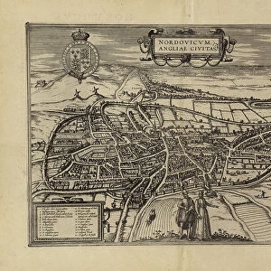
Mouse Mat : Map of Exeter, from Civitates Orbis Terrarum by Georg Braun (1541-1622


![]()
Home Decor from Fine Art Finder
Map of Exeter, from Civitates Orbis Terrarum by Georg Braun (1541-1622
STC138942 Map of Exeter, from Civitates Orbis Terrarum by Georg Braun (1541-1622) and Frans Hogenberg (1535-90) c.1572-1617 (coloured engraving) by Hoefnagel, Joris (1542-1600) (after); Private Collection; The Stapleton Collection; Flemish, out of copyright
Media ID 22783406
© The Stapleton Collection / Bridgeman Images
Atlas Birds Eye View Cities Of The World Crest Devon Elizabethan Jacobean St Peters River Exe
Mouse Pad
Standard Size Mouse Pad 7.75" x 9..25". High density Neoprene w linen surface. Easy to clean, stain resistant finish. Rounded corners.
Archive quality photographic print in a durable wipe clean mouse mat with non slip backing. Works with all computer mice
Estimated Image Size (if not cropped) is 23.7cm x 19.6cm (9.3" x 7.7")
Estimated Product Size is 23.7cm x 20.2cm (9.3" x 8")
These are individually made so all sizes are approximate
Artwork printed orientated as per the preview above, with landscape (horizontal) orientation to match the source image.
FEATURES IN THESE COLLECTIONS
> Fine Art Finder
> Artists
> Joris (after) Hoefnagel
> Fine Art Finder
> Chinese & Korean Art
> Fine Art Finder
> Maps (celestial & Terrestrial)
> Animals
> Mammals
> Muridae
> Peters Mouse
> Arts
> Artists
> H
> Joris Hoefnagel
> Arts
> Landscape paintings
> Waterfall and river artworks
> River artworks
> Europe
> United Kingdom
> England
> Devon
> Exeter
> Europe
> United Kingdom
> England
> Devon
> Related Images
> Europe
> United Kingdom
> England
> Exeter
> Europe
> United Kingdom
> England
> Maps
> Europe
> United Kingdom
> England
> Rivers
> Maps and Charts
> Related Images
> Maps and Charts
> World
EDITORS COMMENTS
This print showcases a remarkable piece of history - the Map of Exeter from Civitates Orbis Terrarum. Created by Georg Braun and Frans Hogenberg in the late 16th century, this coloured engraving offers a mesmerizing birds-eye view of the city during the Elizabethan era. The intricate details on this map transport us back to a time when Exeter was an important hub in England. The coat of arms and crest proudly displayed on the map symbolize the city's significance and power during that period. The River Exe gracefully winds its way through the landscape, highlighting its vital role in trade and transportation. As we explore this exquisite artwork, we can't help but marvel at Joris Hoefnagel's masterful craftsmanship in reproducing such a complex scene. Every street, building, and landmark is meticulously depicted with precision and accuracy. This print not only serves as a visual delight but also provides valuable insights into English history. It captures the essence of life in Exeter during both Jacobean and Tudor times, offering us glimpses into how people lived centuries ago. Whether you are an art enthusiast or a history buff, this Map of Exeter will undoubtedly captivate your imagination. Its rich historical context combined with its stunning artistic execution makes it an invaluable addition to any collection or display.
MADE IN THE USA
Safe Shipping with 30 Day Money Back Guarantee
FREE PERSONALISATION*
We are proud to offer a range of customisation features including Personalised Captions, Color Filters and Picture Zoom Tools
SECURE PAYMENTS
We happily accept a wide range of payment options so you can pay for the things you need in the way that is most convenient for you
* Options may vary by product and licensing agreement. Zoomed Pictures can be adjusted in the Cart.