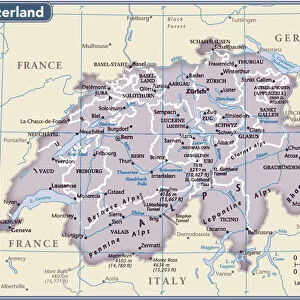
Mouse Mat > Europe > Switzerland > Maps
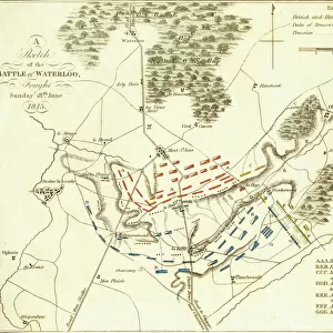
Mouse Mat : Map of the fortified Franco-German frontier between Belgium and Switzerland during World War One, from The History of the Great War, pub.c. 1919

![]()
Home Decor from Fine Art Finder
Map of the fortified Franco-German frontier between Belgium and Switzerland during World War One, from The History of the Great War, pub.c. 1919
3502816 Map of the fortified Franco-German frontier between Belgium and Switzerland during World War One, from The History of the Great War, pub.c. 1919; (add.info.: Map of the fortified Franco-German frontier between Belgium and Switzerland during World War One, from The History of the Great War, pub.c. 1919); Photo © Hilary Morgan
Media ID 38465522
© © Hilary Morgan / Bridgeman Images
1914 1918 Chart Fortified Frontier Belgians Belgium Belgian Franco German Swissman
Mouse Pad
Standard Size Mouse Pad 7.75" x 9..25". High density Neoprene w linen surface. Easy to clean, stain resistant finish. Rounded corners.
Archive quality photographic print in a durable wipe clean mouse mat with non slip backing. Works with all computer mice
Estimated Image Size (if not cropped) is 18.7cm x 23.7cm (7.4" x 9.3")
Estimated Product Size is 20.2cm x 23.7cm (8" x 9.3")
These are individually made so all sizes are approximate
Artwork printed orientated as per the preview above, with portrait (vertical) orientation to match the source image.
FEATURES IN THESE COLLECTIONS
> Fine Art Finder
> Costume & Fashion
> Europe
> Belgium
> Related Images
> Europe
> Switzerland
> Maps
> Europe
> Switzerland
> Posters
> Europe
> Switzerland
> Related Images
> Historic
> World War I and II
> World War I
> Historic
> World War I and II
> Maps and Charts
> Early Maps
EDITORS COMMENTS
This print showcases a detailed map of the fortified Franco-German frontier between Belgium and Switzerland during World War One. Published around 1919, this historical artifact provides a glimpse into the strategic military planning and defensive structures that defined this tumultuous period in European history.
The intricate lines and markings on the map reveal the complex network of fortifications, trenches, and barriers that were established to protect key territories along the border. Each detail tells a story of conflict, resilience, and sacrifice as soldiers from both sides navigated through treacherous terrain in their quest for victory.
As we study this map, we are reminded of the immense challenges faced by those who fought on these frontlines - the courage required to defend one's homeland against enemy forces, the hardships endured in harsh conditions, and the devastating toll that war takes on nations and individuals alike.
Through this visual representation of history, we gain a deeper understanding of the Great War and its lasting impact on generations to come. It serves as a poignant reminder of our shared past and underscores the importance of learning from our collective experiences to strive for peace and unity in an ever-changing world.
MADE IN THE USA
Safe Shipping with 30 Day Money Back Guarantee
FREE PERSONALISATION*
We are proud to offer a range of customisation features including Personalised Captions, Color Filters and Picture Zoom Tools
SECURE PAYMENTS
We happily accept a wide range of payment options so you can pay for the things you need in the way that is most convenient for you
* Options may vary by product and licensing agreement. Zoomed Pictures can be adjusted in the Cart.