Mouse Mat > North America > United States of America > New York > New York > Maps
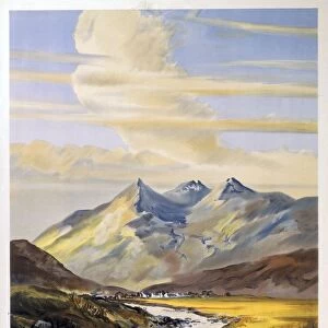
Mouse Mat : Map of New York State, c.1900 (engraving)
")
![]()
Home Decor from Fine Art Finder
Map of New York State, c.1900 (engraving)
533104 Map of New York State, c.1900 (engraving); (add.info.: Map of southern New York State, United States, insets map of New York City, the Hudson River, and the Catskill Mountains, circa 1902, from the 10th edition of Encyclopaedia Britannica.); Encyclopaedia Britannica/UIG
Media ID 38454190
© Encyclopaedia Britannica/UIG / Bridgeman Images
1902 19th Century Style Atlantic Ocean Boundary Catskill Mountains Geographical Border Guidance Hudson River Illustration Technique Navigational Equipment New York State Old Fashioned Part Of Physical Geography State The Past Us State Border Western Script
Mouse Pad
Standard Size Mouse Pad 7.75" x 9..25". High density Neoprene w linen surface. Easy to clean, stain resistant finish. Rounded corners.
Archive quality photographic print in a durable wipe clean mouse mat with non slip backing. Works with all computer mice
Estimated Image Size (if not cropped) is 17.9cm x 23.7cm (7" x 9.3")
Estimated Product Size is 20.2cm x 23.7cm (8" x 9.3")
These are individually made so all sizes are approximate
Artwork printed orientated as per the preview above, with portrait (vertical) orientation to match the source image.
FEATURES IN THESE COLLECTIONS
> Fine Art Finder
> Temp Classification
> Arts
> Artists
> O
> Oceanic Oceanic
> Arts
> Landscape paintings
> Waterfall and river artworks
> River artworks
> Maps and Charts
> Related Images
> North America
> United States of America
> Maps
> North America
> United States of America
> New York
> New York
> Maps
> North America
> United States of America
> New York
> New York
> Related Images
EDITORS COMMENTS
This stunning engraving of a Map of New York State, circa 1900, offers a glimpse into the past with intricate details and historical significance. The map showcases southern New York State, complete with insets of New York City, the Hudson River, and the Catskill Mountains. Created for the 10th edition of Encyclopaedia Britannica, this piece is a testament to the artistry and precision of cartography in the late 19th century.
As you study this map, you can almost feel yourself transported back in time to an era of exploration and discovery. The detailed coastline, boundaries, rivers, and mountains provide a wealth of information about the geography and topography of New York State at that time. The inclusion of navigational equipment symbols adds an element of authenticity to this vintage piece.
Whether you are a history buff or simply appreciate fine art, this print is sure to captivate your imagination. It serves as a reminder of how far we have come in terms of mapping technology while also honoring the craftsmanship and dedication that went into creating maps like these over a century ago. Displaying this Map of New York State in your home will not only add character to your decor but also spark conversations about our rich cultural heritage.
MADE IN THE USA
Safe Shipping with 30 Day Money Back Guarantee
FREE PERSONALISATION*
We are proud to offer a range of customisation features including Personalised Captions, Color Filters and Picture Zoom Tools
SECURE PAYMENTS
We happily accept a wide range of payment options so you can pay for the things you need in the way that is most convenient for you
* Options may vary by product and licensing agreement. Zoomed Pictures can be adjusted in the Cart.