Mouse Mat > Maps and Charts > Early Maps
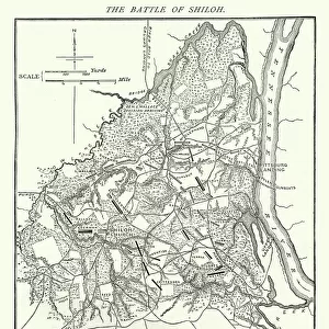
Mouse Mat : Antique Map of St. Lawrence Area during the War of 1812 - 19th Century


![]()
Home Decor from Fine Art Storehouse
Antique Map of St. Lawrence Area during the War of 1812 - 19th Century
Vintage map showing early territorial borders and military positions in the St Lawrence area during the War of 1812. Vintage etching circa late 19th century
Unleash your creativity and transform your space into a visual masterpiece!
powerofforever
Media ID 15149739
© This content is subject to copyright
Territory War Of 1812 Fort Henry Ogdensburg
Mouse Pad
Standard Size Mouse Pad 7.75" x 9..25". High density Neoprene w linen surface. Easy to clean, stain resistant finish. Rounded corners.
Archive quality photographic print in a durable wipe clean mouse mat with non slip backing. Works with all computer mice
Estimated Product Size is 23.7cm x 20.2cm (9.3" x 8")
These are individually made so all sizes are approximate
Artwork printed orientated as per the preview above, with landscape (horizontal) or portrait (vertical) orientation to match the source image.
FEATURES IN THESE COLLECTIONS
> Fine Art Storehouse
> History
> Battles & Wars
> Historcal Battle Maps and Plans
> Fine Art Storehouse
> Map
> Historical Maps
> Historic
> Battles
> Related Images
> Maps and Charts
> Early Maps
> Maps and Charts
> Related Images
MADE IN THE USA
Safe Shipping with 30 Day Money Back Guarantee
FREE PERSONALISATION*
We are proud to offer a range of customisation features including Personalised Captions, Color Filters and Picture Zoom Tools
SECURE PAYMENTS
We happily accept a wide range of payment options so you can pay for the things you need in the way that is most convenient for you
* Options may vary by product and licensing agreement. Zoomed Pictures can be adjusted in the Cart.