Mouse Mat > Europe > United Kingdom > England > London > Related Images
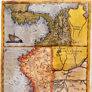
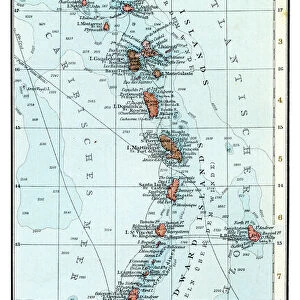
Mouse Mat : Colombia Ecuador Galapagos map 1897

![]()
Home Decor from Fine Art Storehouse
Colombia Ecuador Galapagos map 1897
The World-Wide Atlas of Modern Geography, Political and Physical W. & A.K. Johnston - London 1897
Unleash your creativity and transform your space into a visual masterpiece!
THEPALMER
Media ID 14757134
© Roberto A Sanchez
Atlas Country Geographic Area Earth Ecuador Galapagos Islands Paper World Map Retro Styled
Mouse Pad
Standard Size Mouse Pad 7.75" x 9..25". High density Neoprene w linen surface. Easy to clean, stain resistant finish. Rounded corners.
Archive quality photographic print in a durable wipe clean mouse mat with non slip backing. Works with all computer mice
Estimated Image Size (if not cropped) is 19.5cm x 23.7cm (7.7" x 9.3")
Estimated Product Size is 20.2cm x 23.7cm (8" x 9.3")
These are individually made so all sizes are approximate
Artwork printed orientated as per the preview above, with portrait (vertical) orientation to match the source image.
FEATURES IN THESE COLLECTIONS
> Fine Art Storehouse
> Map
> Historical Maps
> Europe
> United Kingdom
> England
> London
> Related Images
EDITORS COMMENTS
This print showcases a vintage map of Colombia, Ecuador, and the Galapagos Islands from 1897. Taken from "The World-Wide Atlas of Modern Geography" published by W. & A. K. Johnston in London, this piece exudes an air of nostalgia with its retro styling and antique charm. The intricately engraved image transports us back to a time when cartography was meticulously crafted by hand. The delicate lines and intricate details bring to life the physical geography of these South American countries, highlighting their diverse landscapes and natural wonders. Of particular interest is the inclusion of the Galapagos Islands, known for their unique ecosystem that inspired Charles Darwin's theory of evolution. This addition adds a touch of curiosity and adventure to the map, inviting viewers to explore these remote islands teeming with extraordinary flora and fauna. Printed on high-quality paper, this old-world treasure captures not only the geographical beauty but also serves as a testament to human ingenuity in mapping our Earth's vast territories. Whether displayed in a study or living room, this exquisite piece will undoubtedly spark conversations about history, exploration, and our ever-evolving understanding of our planet's geographic areas. "The Colombia Ecuador Galapagos Map 1897" by THEPALMER is more than just art; it is an invitation to embark on a visual journey through time while celebrating the enduring allure of cartography as both science and art form.
MADE IN THE USA
Safe Shipping with 30 Day Money Back Guarantee
FREE PERSONALISATION*
We are proud to offer a range of customisation features including Personalised Captions, Color Filters and Picture Zoom Tools
SECURE PAYMENTS
We happily accept a wide range of payment options so you can pay for the things you need in the way that is most convenient for you
* Options may vary by product and licensing agreement. Zoomed Pictures can be adjusted in the Cart.