Mouse Mat > Europe > Spain > Related Images
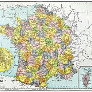
Mouse Mat : Spain and Portugal, lithograph, published in 1878


![]()
Home Decor from Fine Art Storehouse
Spain and Portugal, lithograph, published in 1878
Ancient map of Spain and Portugal. Lithograph, published in 1878
Unleash your creativity and transform your space into a visual masterpiece!
Media ID 13666799
© ZU_09
Atlantic Ocean Balearic Islands Barcelona Spain Country Geographic Area European Culture Gibraltar Ibiza Island Island Lisbon Madrid Majorca Mediterranean Countries Mediterranean Sea Portugal Portuguese Culture Seville Spanish And Portuguese Ethnicity Spanish Culture Topography Valencia Spain Zaragoza Province Straits Of Gibraltar
Mouse Pad
Standard Size Mouse Pad 7.75" x 9..25". High density Neoprene w linen surface. Easy to clean, stain resistant finish. Rounded corners.
Archive quality photographic print in a durable wipe clean mouse mat with non slip backing. Works with all computer mice
Estimated Image Size (if not cropped) is 23.7cm x 19.7cm (9.3" x 7.8")
Estimated Product Size is 23.7cm x 20.2cm (9.3" x 8")
These are individually made so all sizes are approximate
Artwork printed orientated as per the preview above, with landscape (horizontal) orientation to match the source image.
EDITORS COMMENTS
This stunning lithograph, published in 1878, takes us on a captivating journey through the rich history and cultural heritage of Spain and Portugal. The ancient map showcases the intricate topography of these Mediterranean countries, with a particular focus on the Zaragoza province. As we explore this engraved image, we are transported to a bygone era when cartography was both an art form and a scientific endeavor. The lithograph reveals the strategic importance of the Straits of Gibraltar, connecting the Mediterranean Sea to the Atlantic Ocean. It highlights major cities such as Seville, Madrid, Valencia, Barcelona in Spain and Lisbon in Portugal. The Balearic Islands - Ibiza and Majorca - dotting the coastline add an enchanting touch to this historical masterpiece. As we delve into this antique print, it becomes evident that it is more than just a geographical representation; it encapsulates Spanish and Portuguese culture intertwined with their ethnic identities. This vertical composition allows us to appreciate every detail meticulously captured by skilled hands over a century ago. In 2015, this photograph preserves not only our fascination for old maps but also serves as a reminder of how far we have come since then. Its presence outdoors evokes nostalgia for times past while reminding us that these two countries continue to be cherished destinations for travelers seeking European charm.
MADE IN THE USA
Safe Shipping with 30 Day Money Back Guarantee
FREE PERSONALISATION*
We are proud to offer a range of customisation features including Personalised Captions, Color Filters and Picture Zoom Tools
SECURE PAYMENTS
We happily accept a wide range of payment options so you can pay for the things you need in the way that is most convenient for you
* Options may vary by product and licensing agreement. Zoomed Pictures can be adjusted in the Cart.