Mouse Mat > Europe > Austria > Lakes > Lake Constance
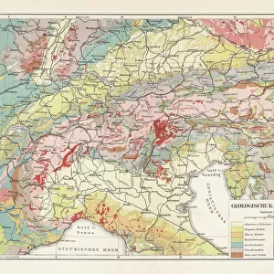
Mouse Mat : Topographic map of the European Alps, lithograph, published in 1897


![]()
Home Decor from Fine Art Storehouse
Topographic map of the European Alps, lithograph, published in 1897
Topographic map of the European Alps. Lithograph, published in 1897
Unleash your creativity and transform your space into a visual masterpiece!
Media ID 14756396
© This content is subject to copyright
Alps Austria Croatia European Alps European Culture Istria Lake Constance Lake Garda Lake Geneva Mediterranean Sea Milan Munich Slovenia Switzerland Topographic Map Topography Turin Adria Gulf Of Genoa Gulf Of Venice Topographic
Mouse Pad
Standard Size Mouse Pad 7.75" x 9..25". High density Neoprene w linen surface. Easy to clean, stain resistant finish. Rounded corners.
Archive quality photographic print in a durable wipe clean mouse mat with non slip backing. Works with all computer mice
Estimated Image Size (if not cropped) is 23.7cm x 15cm (9.3" x 5.9")
Estimated Product Size is 23.7cm x 20.2cm (9.3" x 8")
These are individually made so all sizes are approximate
Artwork printed orientated as per the preview above, with landscape (horizontal) orientation to match the source image.
FEATURES IN THESE COLLECTIONS
> Fine Art Storehouse
> Map
> Historical Maps
> Fine Art Storehouse
> Map
> Italian Maps
> Fine Art Storehouse
> Travel Imagery
> Travel Destinations
> Venice, Italy
> Arts
> Contemporary art
> Landscapes
> Mountain landscapes
> Arts
> Landscape paintings
> Landscape art
> Landscape paintings
> Arts
> Landscape paintings
> Landscape art
> Mountain landscapes
> Europe
> Austria
> Lakes
> Lake Constance
> Europe
> Austria
> Lakes
> Related Images
> Europe
> Austria
> Related Images
EDITORS COMMENTS
This lithograph, published in 1897, showcases a topographic map of the majestic European Alps. Stretching across multiple countries including Switzerland, Italy, France, Germany, Austria, and Slovenia, this mountain range is a true testament to the beauty of European culture and geography. With intricate detail and precision engraving techniques employed by skilled artisans of that era, this print offers a glimpse into the topography of the region. From its peaks to valleys and everything in between, every contour is meticulously captured on this horizontal landscape. As you explore this vintage masterpiece further, your eyes will wander along the coastline where it meets both the Mediterranean Sea and Adria. The map also highlights notable landmarks such as Turin, Munich Milan Croatia's stunning lakes - Lake Geneva , Lake Constance , and Lake Garda- as well as Gulf of Genoa and Gulf of Venice. Whether you are an avid hiker planning your next adventure or simply an admirer of historical cartography, this lithograph serves as a window into Europe's breathtaking alpine terrain. Its timeless charm transports us back to an era when maps were not just utilitarian tools but works of art themselves.
MADE IN THE USA
Safe Shipping with 30 Day Money Back Guarantee
FREE PERSONALISATION*
We are proud to offer a range of customisation features including Personalised Captions, Color Filters and Picture Zoom Tools
SECURE PAYMENTS
We happily accept a wide range of payment options so you can pay for the things you need in the way that is most convenient for you
* Options may vary by product and licensing agreement. Zoomed Pictures can be adjusted in the Cart.