Mouse Mat > North America > United States of America > New York > New York > Maps
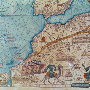
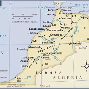
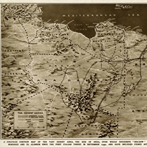
Mouse Mat : Map of Morocco 1883


![]()
Home Decor from Fine Art Storehouse
Map of Morocco 1883
Encyclopedia Britannica 9th Edition New York Samuel L. Hall 1883 Vol XVI
Unleash your creativity and transform your space into a visual masterpiece!
THEPALMER
Media ID 14756752
© This content is subject to copyright
Mouse Pad
Standard Size Mouse Pad 7.75" x 9..25". High density Neoprene w linen surface. Easy to clean, stain resistant finish. Rounded corners.
Archive quality photographic print in a durable wipe clean mouse mat with non slip backing. Works with all computer mice
Estimated Image Size (if not cropped) is 23.7cm x 18.2cm (9.3" x 7.2")
Estimated Product Size is 23.7cm x 20.2cm (9.3" x 8")
These are individually made so all sizes are approximate
Artwork printed orientated as per the preview above, with landscape (horizontal) orientation to match the source image.
FEATURES IN THESE COLLECTIONS
> Fine Art Storehouse
> Map
> Historical Maps
> Fine Art Storehouse
> Travel Imagery
> Travel Destinations
> Morocco, North Africa
> Fine Art Storehouse
> Ultimate Earth Prints
> Amazing Deserts
> Africa
> Algeria
> Related Images
> Africa
> Morocco
> Related Images
> Animals
> Mammals
> Muridae
> Desert Mouse
> Maps and Charts
> Related Images
> North America
> United States of America
> New York
> New York
> Maps
> North America
> United States of America
> New York
> Related Images
EDITORS COMMENTS
In this print titled "Map of Morocco 1883" we are transported back in time to the enchanting landscapes and rich history of North Africa. The image showcases a meticulously detailed map, sourced from the renowned Encyclopedia Britannica 9th Edition, New York, Samuel L. Hall 1883 Vol XVI. The map itself is a testament to the artistry and dedication of cartographers from that era, capturing every intricate detail of Morocco's geography with precision. From the vast Sahara Desert stretching across its southern borders to the bustling city of Fez nestled amidst picturesque mountain ranges, this map offers a glimpse into an era long gone. As we explore this vintage treasure by THEPALMER through our eyes, it sparks curiosity about how travelers once navigated these lands without modern technology or satellite imagery. It serves as a reminder of Morocco's historical significance as a crossroads between Europe and Africa. This print transports us beyond mere geographical boundaries; it evokes emotions and ignites wanderlust for those who yearn to immerse themselves in Moroccan culture – vibrant markets filled with spices and textiles, ancient medinas adorned with stunning architecture, and nomadic tribes traversing endless dunes under starlit skies. "The Map of Morocco 1883" by THEPALMER is not just an artistic representation but also an invitation to embark on a journey through time – allowing us to appreciate both the beauty captured within its borders and the stories waiting to be discovered beyond them.
MADE IN THE USA
Safe Shipping with 30 Day Money Back Guarantee
FREE PERSONALISATION*
We are proud to offer a range of customisation features including Personalised Captions, Color Filters and Picture Zoom Tools
SECURE PAYMENTS
We happily accept a wide range of payment options so you can pay for the things you need in the way that is most convenient for you
* Options may vary by product and licensing agreement. Zoomed Pictures can be adjusted in the Cart.