Mouse Mat > Asia > Israel > Jerusalem Heritage Sites > Old City of Jerusalem and its Walls
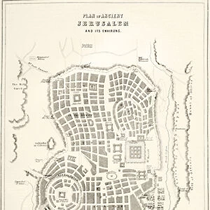
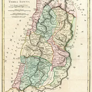
Mouse Mat : Map of the ancient Jerusalem, copperplate engraving, published in 1774


![]()
Home Decor from Fine Art Storehouse
Map of the ancient Jerusalem, copperplate engraving, published in 1774
Map of the ancient Jerusalem. Copperplate engraving, published in 1774
Unleash your creativity and transform your space into a visual masterpiece!
Media ID 14756504
© This content is subject to copyright
Bible Calvary Cartouche City Map Copper Engraving Historically Israel Jerusalem Judaism Nostalgia Nostalgic Palestine Plan Temple Bethesda Geschichte Gethsemane Gravur Historisch Karte Palestina Querformat Stadt Stich Tempel
Mouse Pad
Standard Size Mouse Pad 7.75" x 9..25". High density Neoprene w linen surface. Easy to clean, stain resistant finish. Rounded corners.
Archive quality photographic print in a durable wipe clean mouse mat with non slip backing. Works with all computer mice
Estimated Image Size (if not cropped) is 23.7cm x 16.3cm (9.3" x 6.4")
Estimated Product Size is 23.7cm x 20.2cm (9.3" x 8")
These are individually made so all sizes are approximate
Artwork printed orientated as per the preview above, with landscape (horizontal) orientation to match the source image.
FEATURES IN THESE COLLECTIONS
> Fine Art Storehouse
> Map
> Historical Maps
> Fine Art Storehouse
> World Religion
> Arts
> Landscape paintings
> Landscape art
> Landscape paintings
> Asia
> Israel
> Jerusalem Heritage Sites
> Old City of Jerusalem and its Walls
> Asia
> Israel
> Related Images
> Asia
> Palestine
> Jerusalem
> Asia
> Palestine
> Related Images
> Maps and Charts
> Early Maps
> Maps and Charts
> Related Images
EDITORS COMMENTS
This copperplate engraving, published in 1774, offers a mesmerizing glimpse into the ancient city of Jerusalem. The meticulously detailed map takes us on a journey through time, immersing us in the rich history and religious significance that this holy land holds. As our eyes wander across the landscape, we are transported to iconic landmarks such as the Temple Mount, Gethsemane, Bethesda, and Calvary. Each stroke of the engraver's hand brings to life these sacred sites that have played pivotal roles in both Judaism and Christianity. The map's horizontal layout allows for an expansive view of Jerusalem's streets and alleys, inviting us to explore its labyrinthine pathways. Its antique charm evokes nostalgia for a bygone era when pilgrims traversed these very streets with reverence and awe. With every glance at this historic masterpiece, we are reminded of the enduring power of faith and how it has shaped human civilization throughout centuries. It serves as a testament to the profound influence Jerusalem continues to exert on believers from all corners of the globe. Whether you are an avid historian or simply captivated by ancient wonders, this remarkable print is sure to transport you back in time. Let yourself be enchanted by its intricate details and immerse yourself in the storied past of one of humanity's most cherished cities.
MADE IN THE USA
Safe Shipping with 30 Day Money Back Guarantee
FREE PERSONALISATION*
We are proud to offer a range of customisation features including Personalised Captions, Color Filters and Picture Zoom Tools
SECURE PAYMENTS
We happily accept a wide range of payment options so you can pay for the things you need in the way that is most convenient for you
* Options may vary by product and licensing agreement. Zoomed Pictures can be adjusted in the Cart.