Mouse Mat > Arts > Artists > B > Willem Blaeu
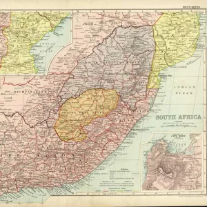
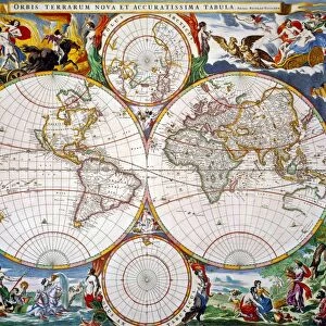
Mouse Mat : MAP OF AFRICA, 1630. Willem Blaeus ornamental map of Africa Newly Described


![]()
Home Decor from Granger
MAP OF AFRICA, 1630. Willem Blaeus ornamental map of Africa Newly Described
MAP OF AFRICA, 1630.
Willem Blaeus ornamental map of Africa Newly Described
Granger holds millions of images spanning more than 25,000 years of world history, from before the Stone Age to the dawn of the Space Age
Media ID 6617703
1630 Africa African Blaeu Janszoon Willem
Mouse Pad
Standard Size Mouse Pad 7.75" x 9..25". High density Neoprene w linen surface. Easy to clean, stain resistant finish. Rounded corners.
Archive quality photographic print in a durable wipe clean mouse mat with non slip backing. Works with all computer mice
Estimated Image Size (if not cropped) is 23.7cm x 18.2cm (9.3" x 7.2")
Estimated Product Size is 23.7cm x 20.2cm (9.3" x 8")
These are individually made so all sizes are approximate
Artwork printed orientated as per the preview above, with landscape (horizontal) orientation to match the source image.
FEATURES IN THESE COLLECTIONS
> Granger Art on Demand
> Maps
> Africa
> Related Images
> Arts
> Artists
> B
> Willem Blaeu
> Arts
> Landscape paintings
> Waterfall and river artworks
> River artworks
> Maps and Charts
> Related Images
> Maps and Charts
> Willem Janszoon Blaeu
EDITORS COMMENTS
This print showcases the stunning "Map of Africa, 1630" by Willem Blaeu. Renowned for his ornamental cartography, Blaeu's masterpiece offers a fascinating glimpse into the African continent during the 17th century. The intricately detailed map is aptly titled "Newly Described" as it presents a comprehensive and accurate representation of Africa at that time. The rich hues and intricate illustrations on this vintage map transport viewers back to an era when exploration was at its peak. Every river, mountain range, and city is meticulously depicted with precision and artistry. This visual feast allows us to appreciate not only the geographical features but also the cultural diversity that defines Africa. Willem Janszoon Blaeu's expertise in cartography shines through in this remarkable piece of art. His dedication to accuracy combined with his artistic flair creates a harmonious balance between science and aesthetics. As we gaze upon this historic artifact, we are reminded of how maps have always been more than just navigational tools; they are windows into our collective past. With its timeless appeal, this Granger Collection print serves as both an educational resource and a decorative piece for any space. Whether you're an avid history enthusiast or simply captivated by Africa's beauty, this exquisite map invites you to embark on a journey through time while celebrating the rich heritage of one of Earth's most diverse continents.
MADE IN THE USA
Safe Shipping with 30 Day Money Back Guarantee
FREE PERSONALISATION*
We are proud to offer a range of customisation features including Personalised Captions, Color Filters and Picture Zoom Tools
SECURE PAYMENTS
We happily accept a wide range of payment options so you can pay for the things you need in the way that is most convenient for you
* Options may vary by product and licensing agreement. Zoomed Pictures can be adjusted in the Cart.