Mouse Mat > Arts > Artists > E > Alfred East
Mouse Mat : Alfreds Last War - Opening Phases. From about October 892-March 893, (1935)
")
![]()
Home Decor from Heritage Images
Alfreds Last War - Opening Phases. From about October 892-March 893, (1935)
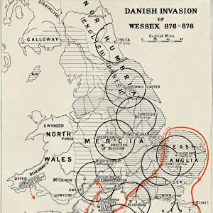
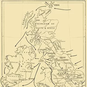
Alfreds Last War - Opening Phases. From about October 892-March 893, (1935). Map of the south-east of England, showing Burhs (Old English fortifications) of the Anglo-Saxon King Alfred the Great, Danish forts, and significant sites during the period of Viking invasion. From A History of the Anglo-Saxons, Vol. II, by R. H. Hodgkin. [The Clarendon Press, Oxford, 1935]
Heritage Images features heritage image collections
Media ID 15466658
© The Print Collector / Heritage-Images
9th Century Aelfred Alfred I Alfred The Great Anglo Saxon Fort Forts Invasion King Alfred King Alfred The Great King Of Wessex Viking
Mouse Pad
Standard Size Mouse Pad 7.75" x 9..25". High density Neoprene w linen surface. Easy to clean, stain resistant finish. Rounded corners.
Archive quality photographic print in a durable wipe clean mouse mat with non slip backing. Works with all computer mice
Estimated Product Size is 20.2cm x 23.7cm (8" x 9.3")
These are individually made so all sizes are approximate
Artwork printed orientated as per the preview above, with portrait (vertical) orientation to match the source image.
FEATURES IN THESE COLLECTIONS
> Arts
> Artists
> D
> Alfred
> Related Images
> Arts
> Artists
> E
> Alfred East
> Arts
> Minimalist artwork
> Monochrome artwork
> Fine art
> Arts
> Minimalist artwork
> Monochrome artwork
> Monochrome paintings
> Europe
> Denmark
> Related Images
> Europe
> United Kingdom
> England
> Maps
> Europe
> United Kingdom
> England
> Oxford
Alfred's Last War - Opening Phases - A Glimpse into the Viking Invasion of England
EDITORS COMMENTS
. This print takes us back to a crucial period in history, capturing the opening phases of Alfred's Last War from October 892 to March 893. The image showcases a detailed map of the south-east of England, revealing an intricate network of Burhs – ancient fortifications built by King Alfred the Great during his reign as he defended his kingdom against Danish invaders. The monochrome aesthetics add a sense of timelessness and mystery to this historical artifact, transporting us to both the 9th century and early 20th century when this print was published. It serves as a visual testament to the resilience and strategic brilliance displayed by King Alfred I, also known as Alfred the Great. Every line on this map tells a story – each dot representing significant sites where battles were fought or defenses were erected. As we explore this image further, our eyes are drawn towards Danish forts scattered along the coastlines, reminding us of their relentless attempts at invasion. This photograph not only captures an important chapter in British history but also highlights how warfare has shaped nations throughout centuries. It stands as a reminder that even amidst chaos and conflict, great leaders like King Alfred can emerge with determination and courage. Credit: The Print Collector/Heritage Images
MADE IN THE USA
Safe Shipping with 30 Day Money Back Guarantee
FREE PERSONALISATION*
We are proud to offer a range of customisation features including Personalised Captions, Color Filters and Picture Zoom Tools
SECURE PAYMENTS
We happily accept a wide range of payment options so you can pay for the things you need in the way that is most convenient for you
* Options may vary by product and licensing agreement. Zoomed Pictures can be adjusted in the Cart.