Mouse Mat > Europe > France > Canton > Nord
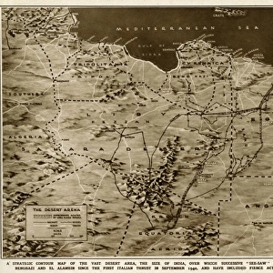
Mouse Mat : Le Climat, distribution des pluies; Afrique du nord, 1914. Creator: Unknown


![]()
Home Decor from Heritage Images
Le Climat, distribution des pluies; Afrique du nord, 1914. Creator: Unknown
Le Climat, distribution des pluies; Afrique du nord, 1914. From "Grande Geographie Bong Illustree", 1914
Heritage Images features heritage image collections
Media ID 36294833
© The Print Collector/Heritage Images
Algeria Atlantic Ocean Atlas Mountains Cartography Climate Desert Map Making Mapmaking Mediterranean Sea Morocco Mountain Range North Africa North African Ocean Sahara Sahara Desert Africa Tunisia Rainfall
Mouse Pad
Standard Size Mouse Pad 7.75" x 9..25". High density Neoprene w linen surface. Easy to clean, stain resistant finish. Rounded corners.
Archive quality photographic print in a durable wipe clean mouse mat with non slip backing. Works with all computer mice
Estimated Image Size (if not cropped) is 23.7cm x 11.2cm (9.3" x 4.4")
Estimated Product Size is 23.7cm x 20.2cm (9.3" x 8")
These are individually made so all sizes are approximate
Artwork printed orientated as per the preview above, with landscape (horizontal) orientation to match the source image.
FEATURES IN THESE COLLECTIONS
> Africa
> Algeria
> Related Images
> Africa
> Morocco
> Related Images
> Africa
> Tunisia
> Related Images
> Animals
> Mammals
> Muridae
> Desert Mouse
> Europe
> France
> Canton
> Nord
Le Climat, distribution des pluies; Afrique du Nord
EDITORS COMMENTS
(The Climate, Distribution of Rains; North Africa), created in 1914, is an intriguing and captivating print that showcases the climatic conditions and geographical features of North Africa during the early 20th century. The image, published in "Grande Geographie Bong Illustree," provides a detailed representation of the rainfall patterns across North Africa, including the Sahara Desert and the Atlantic and Mediterranean coasts. The print displays the North African continent with an emphasis on the distribution of rainfall, highlighting the stark contrast between the arid Sahara Desert in the south and the more temperate regions along the Mediterranean and Atlantic coasts. The Atlas Mountains, a significant mountain range that runs through Algeria, Morocco, and Tunisia, are also depicted, separating the coastal areas from the desert. The Atlantic and Mediterranean seas are featured prominently, with the Atlantic Ocean extending along the western coast and the Mediterranean Sea along the northern coast. The print also includes the names of various countries, including Algeria, Morocco, and Tunisia, and major geographical features such as the Sahara Desert and the Sahara Africa. The print's creation in 1914 reflects the era of mapmaking and cartography during the early 20th century, when exploration and understanding of the world's geography were a significant focus. The image's engraving technique adds to its historical and nostalgic appeal, making it an essential addition to any collection of vintage maps or African studies. Despite the print's unknown creator, its intricate detail and accuracy make it a valuable resource for understanding the climatic and geographical conditions of North Africa during the early 1900s. The print's timeless beauty and historical significance make it a fascinating piece of visual history, worthy of display and appreciation.
MADE IN THE USA
Safe Shipping with 30 Day Money Back Guarantee
FREE PERSONALISATION*
We are proud to offer a range of customisation features including Personalised Captions, Color Filters and Picture Zoom Tools
SECURE PAYMENTS
We happily accept a wide range of payment options so you can pay for the things you need in the way that is most convenient for you
* Options may vary by product and licensing agreement. Zoomed Pictures can be adjusted in the Cart.