Mouse Mat > Maps and Charts > Related Images
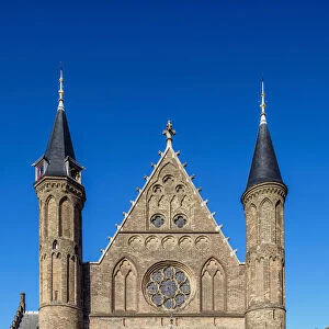
Mouse Mat : Map Hyberniae regni provincias Ultoniam Connacham

![]()
Home Decor from Liszt Collection
Map Hyberniae regni provincias Ultoniam Connacham
Map, Hyberniae regni in provincias Ultoniam, Connacham, Lageniam, Momoniamq. divisi tabula accuratissima, Carel Allard (1648-1709), Copperplate print
Liszt Collection of nineteenth-century engravings and images to browse and enjoy
Media ID 19585343
© Artokoloro
1648 1709 Carel Allard Copperplate Print
Mouse Pad
Standard Size Mouse Pad 7.75" x 9..25". High density Neoprene w linen surface. Easy to clean, stain resistant finish. Rounded corners.
Archive quality photographic print in a durable wipe clean mouse mat with non slip backing. Works with all computer mice
Estimated Product Size is 20.2cm x 23.7cm (8" x 9.3")
These are individually made so all sizes are approximate
Artwork printed orientated as per the preview above, with portrait (vertical) orientation to match the source image.
EDITORS COMMENTS
This print showcases a remarkable piece of cartographic artistry from the Liszt Collection. The image features an intricately detailed map titled "Map Hyberniae regni provincias Ultoniam Connacham" by the talented Dutch engraver, Carel Allard (1648-1709). Crafted using copperplate printing techniques, this exquisite work captures the essence of Ireland's ancient provinces - Ulster, Connacht, Leinster, and Munster. Allard's meticulous attention to detail is evident in every inch of this accurate and beautifully rendered map. From the delicate lines tracing rivers and coastlines to the precisely labeled cities and towns, each element contributes to a comprehensive understanding of Ireland's geographical layout during that era. The rich historical significance of this map cannot be overstated. It offers a glimpse into Ireland's past, providing valuable insights into its political divisions and regional boundaries. As viewers engage with this print, they are transported back in time to an era when maps were not only navigational tools but also works of art. Whether you are an avid collector or simply appreciate fine craftsmanship and historical artifacts, this print is sure to captivate your imagination. Display it proudly in your home or office as a testament to both Allard's skill as an engraver and Ireland's enduring legacy as a land steeped in history and culture.
MADE IN THE USA
Safe Shipping with 30 Day Money Back Guarantee
FREE PERSONALISATION*
We are proud to offer a range of customisation features including Personalised Captions, Color Filters and Picture Zoom Tools
SECURE PAYMENTS
We happily accept a wide range of payment options so you can pay for the things you need in the way that is most convenient for you
* Options may vary by product and licensing agreement. Zoomed Pictures can be adjusted in the Cart.