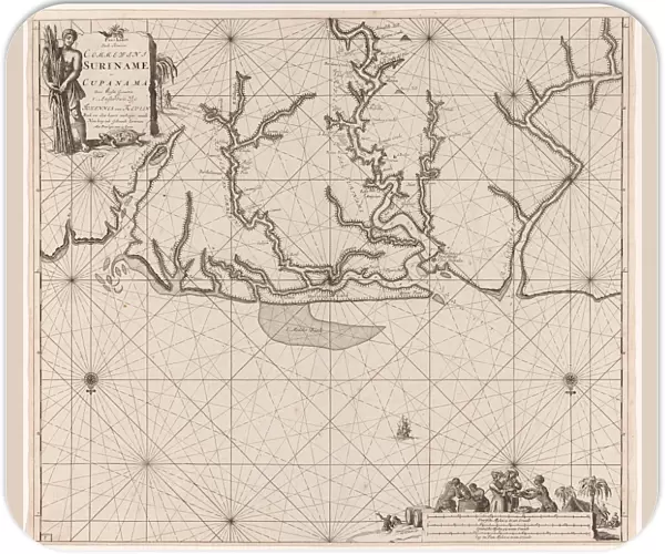
Mouse Mat : Sea chart of various Surinamese rivers, Jan Luyken, Johannes van Keulen (I), unknown
![]()

Home Decor from Liszt Collection
Sea chart of various Surinamese rivers, Jan Luyken, Johannes van Keulen (I), unknown
Sea chart of various Surinamese rivers, Jan Luyken, Johannes van Keulen (I), unknown, 1684 - 1799
Liszt Collection of nineteenth-century engravings and images to browse and enjoy
Media ID 12716223
© Quint Lox Limited
1684 1799 Address Atlantic Cane Compass Compass Roses Dark Estuary French Miles Jan Luyken Johannes Van Keulen Mouth North Production Rivers Roses Sea Chart Sugar Suriname Test Tortoises Trade Traders Trial Trials Turtle Turtles Paramaribo Sugar Cane Suriname River Surinamese
Mouse Pad
Standard Size Mouse Pad 7.75" x 9..25". High density Neoprene w linen surface. Easy to clean, stain resistant finish. Rounded corners.
Archive quality photographic print in a durable wipe clean mouse mat with non slip backing. Works with all computer mice
Estimated Product Size is 23.7cm x 20.2cm (9.3" x 8")
These are individually made so all sizes are approximate
Artwork printed orientated as per the preview above, with landscape (horizontal) orientation to match the source image.
EDITORS COMMENTS
This print showcases a remarkable sea chart depicting various Surinamese rivers, created by the talented duo Jan Luyken and Johannes van Keulen (I) in the late 17th to 18th century. The intricate details of this map offer a glimpse into the world of cartography during that era. The chart vividly portrays the expansive network of rivers flowing through Suriname, including Commewijne, Coppenameriver, and Suriname River. These waterways were vital for trade and transportation in this region known for its sugar production. As we explore the map further, our eyes are drawn to beautifully illustrated compass roses indicating cardinal directions. They guide sailors navigating across the vast Atlantic Ocean towards Paramaribo's estuary – an important hub for traders at that time. Notably, amidst these geographical features lies an intriguing scene featuring dark-skinned men laboring in sugarcane fields while turtles roam nearby. This depiction provides us with a glimpse into the historical context of slavery and colonialism prevalent during this period. Quint Lox has skillfully captured every detail of this historic print from Liszt Collection, allowing us to appreciate both its artistic beauty and historical significance. It serves as a testament to humanity's continuous quest for exploration and understanding of our world's geography throughout centuries past.
MADE IN THE USA
Safe Shipping with 30 Day Money Back Guarantee
FREE PERSONALISATION*
We are proud to offer a range of customisation features including Personalised Captions, Color Filters and Picture Zoom Tools
SECURE PAYMENTS
We happily accept a wide range of payment options so you can pay for the things you need in the way that is most convenient for you
* Options may vary by product and licensing agreement. Zoomed Pictures can be adjusted in the Cart.


