Mouse Mat > Europe > France > Canton > Allier
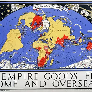
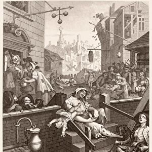
Mouse Mat : Map, Britain -- Spearhead of Attack, WW2


![]()
Home Decor from Mary Evans Picture Library
Map, Britain -- Spearhead of Attack, WW2
Map, Britain -- Spearhead of Attack, WW2. Date: 1940s
Mary Evans Picture Library makes available wonderful images created for people to enjoy over the centuries
Media ID 14146038
© Mary Evans Picture Library/Onslow Auctions Limited
Allied Allies Attack Bombing Bombs Defence Effort Isles Manufacture Spearhead
Mouse Pad
Standard Size Mouse Pad 7.75" x 9..25". High density Neoprene w linen surface. Easy to clean, stain resistant finish. Rounded corners.
Archive quality photographic print in a durable wipe clean mouse mat with non slip backing. Works with all computer mice
Estimated Image Size (if not cropped) is 23.7cm x 16.4cm (9.3" x 6.5")
Estimated Product Size is 23.7cm x 20.2cm (9.3" x 8")
These are individually made so all sizes are approximate
Artwork printed orientated as per the preview above, with landscape (horizontal) orientation to match the source image.
FEATURES IN THESE COLLECTIONS
> Animals
> Mammals
> Muridae
> Fortior
> Europe
> France
> Canton
> Allier
> Europe
> Republic of Ireland
> Maps
> Europe
> United Kingdom
> Maps
> Historic
> World War I and II
> World War II
> Maps and Charts
> Early Maps
EDITORS COMMENTS
This evocative map print, titled "Map, Britain -- Spearhead of Attack, WW2," transports us back in time to the tumultuous 1940s during the Second World War. The intricate detail of the map reveals the strategic locations of the British Isles, Ireland, and parts of Europe, with a particular focus on the United Kingdom. The map serves as a testament to the critical role Britain played during this global conflict. The map is adorned with various symbols and notations, indicating key military installations, ports, and industrial centers. The red dots scattered across the map represent bombing raids, a stark reminder of the relentless air attacks that the British people endured. The presence of the British, American, and Allied flags signifies the unity and solidarity of the Allied forces in their joint efforts to defend against the Axis powers, primarily Germany. The map also highlights the importance of the British Navy, with various naval bases and shipping routes marked. The Royal Navy was instrumental in protecting the British Isles from invasion and maintaining the supply lines to the Allied forces in Europe. This map print offers a unique perspective on the historical context of the 1940s, showcasing the intricate planning and strategic maneuvers that were essential to the war effort. The intricate details and accurate depictions make it an invaluable resource for historians, military enthusiasts, and anyone interested in understanding the complexities of the Second World War.
MADE IN THE USA
Safe Shipping with 30 Day Money Back Guarantee
FREE PERSONALISATION*
We are proud to offer a range of customisation features including Personalised Captions, Color Filters and Picture Zoom Tools
SECURE PAYMENTS
We happily accept a wide range of payment options so you can pay for the things you need in the way that is most convenient for you
* Options may vary by product and licensing agreement. Zoomed Pictures can be adjusted in the Cart.